Back جغرافيا بوليفيا Arabic Xeografía de Bolivia AST География на Боливия Bulgarian Geographie Boliviens German Γεωγραφία της Βολιβίας Greek Geografía de Bolivia Spanish جغرافیای بولیوی Persian Bolivian maantiede Finnish Géographie de la Bolivie French Geografia della Bolivia Italian

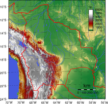
The geography of Bolivia includes the Eastern Andes Mountain Range (also called the Cordillera Oriental) which bisects Bolivia roughly from north to south. To the east of that mountain chain are lowland plains of the Amazon Basin, and to the west is the Altiplano which is a highland plateau where Lake Titicaca is located. Bolivia's geography has features similar to those of Peru which abuts Bolivia's northwest border; like Bolivia, Peru is bisected from north to south by the Eastern Andes Mountains, and these two countries share Lake Titicaca which is the highest navigable lake on Earth. Unlike Peru, however, Bolivia is one of the two landlocked countries in South America, the other being Paraguay, which is located along Bolivia's southeast border.
© MMXXIII Rich X Search. We shall prevail. All rights reserved. Rich X Search