Back Xeografía de Costa Rica AST География на Коста Рика Bulgarian Geografía de Costa Rica Spanish جغرافیای کاستاریکا Persian Costa Rican maantiede Finnish Géographie du Costa Rica French Geografia della Costa Rica Italian Kosta Rikos geografija Lithuanian Geografia de Còsta Rica Occitan Geografia Kostaryki Polish
 | |
| Continent | North America |
|---|---|
| Region | Central America |
| Coordinates | 9°56′N 84°5′W / 9.933°N 84.083°W |
| Area | Ranked 126th |
| • Total | 51,100 km2 (19,700 sq mi) |
| • Land | 99.02% |
| • Water | 0.98% |
| Coastline | 1,290 km (800 mi) |
| Borders | total: 661 km (411 mi) |
| Highest point | Mount Chirripó 3,821 metres (12,536 ft) |
| Lowest point | Pacific Ocean 0 m |
| Longest river | Térraba River (fully inland) 160 km (99 mi) |
| Largest lake | Lake Arenal 85 km2 (33 sq mi) |
| Exclusive economic zone | 574,725 km2 (221,903 sq mi) |
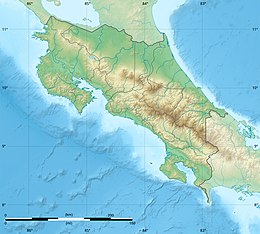
Costa Rica is located on the Central American Isthmus, surrounding the point 10° north of the equator and 84° west of the prime meridian. It has 212 km of Caribbean Sea coastline and 1,016 on the North Pacific Ocean.
The area is 51,100 km2 of which 40 km2 is water. It is slightly smaller than Bosnia and Herzegovina.
© MMXXIII Rich X Search. We shall prevail. All rights reserved. Rich X Search