Back جغرافيا موريشيوس Arabic Xeografía de Mauriciu AST Геаграфія Маўрыкія Byelorussian Γεωγραφία του Μαυρικίου Greek Geografía de Mauricio Spanish جغرافیای موریس Persian Géographie de Maurice French Geografi Mauritius Malay Geografia Mauritiusa Polish Geografia da Maurícia Portuguese
Native name: Moris Nickname: The Star and Key of the Indian Ocean | |
|---|---|
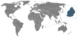
 Location of Mauritius | |
 | |
| Geography | |
| Location | Indian Ocean |
| Coordinates | 20°17′S 57°33′E / 20.283°S 57.550°E |
| Archipelago | Mascarene Islands |
| Area | 2,011 km2 (776 sq mi) |
| Highest elevation | 828 m (2717 ft) |
| Highest point | Piton de la Petite Rivière Noire |
| Administration | |
| Largest settlement | Port Louis (pop. 147,688) |
| Demographics | |
| Population | 1,264,866 (2007) |
| Pop. density | 616/km2 (1595/sq mi) |
| Ethnic groups | Indo-Mauritian 68%, Mauritian Creole people 27%, Sino-Mauritian 3%, Franco-Mauritian 2% |
Mauritius is an island off Africa's southeast coast located in the Indian Ocean, east of Madagascar. It is geologically located within the Somali plate.
© MMXXIII Rich X Search. We shall prevail. All rights reserved. Rich X Search