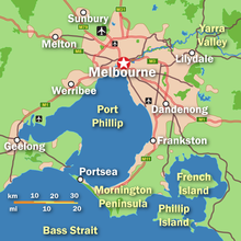


Melbourne, the capital city of Victoria, Australia, is situated on the southeastern fringe of the Australian landmass and in the southern central part of the state. Melbourne covers an urbanised area (generally excluding nearby rural areas) of approximately 2,453 km2–larger than that of Sydney, Greater London and Mexico City,[1] with population density roughly around 16 people per hectare on average.[1][2][3]
The city itself is situated in a region of alpine forests known as the High Country. The city and metropolitan areas of Melbourne also spans along the lower stretches of the Yarra River. Towards eastern Melbourne is the low-lying mountain ranges known as Dandenong Ranges, 35 km east of the city.
- ^ a b "Australian cities among the largest and least densely settled in the world". architectureau.com. 20 April 2017. Retrieved 6 May 2020.
- ^ Mees, Paul (22 November 2009). "We can keep our leafy suburbs and still save the planet". The Age. Retrieved 14 June 2020.
- ^ "How big is Melbourne?". The Melbourne Urbanist. 25 March 2010. Retrieved 14 June 2020.
© MMXXIII Rich X Search. We shall prevail. All rights reserved. Rich X Search
