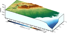

The geography of North Carolina falls naturally into three divisions — the Appalachian Mountains in the west (including the Blue Ridge and Great Smoky Mountains), the central Piedmont Plateau, and the eastern Atlantic Coastal Plain. North Carolina covers 53,819 square miles (139,391 km2) and is 503 miles (810 km) wide by 150 miles (241 km) long. The physical characteristics of the state vary from the summits of the Smoky Mountains, an altitude of near seven thousand feet (2,130 m) in the west, sloping eastward to sea level along the coast and beaches of the Atlantic Ocean.
© MMXXIII Rich X Search. We shall prevail. All rights reserved. Rich X Search
