Back Geografia del Tibet Catalan Geografie Tibetu Czech جغرافیای تبت Persian Géographie du Tibet French Tibet földrajza Hungarian Geografia do Tibete Portuguese Климат Тибета Russian Geografija Tibeta Slovenian Клімат Тибету Ukrainian 西藏地理 Chinese

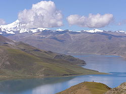
The geography of Tibet consists of the high mountains, lakes and rivers lying between Central, East and South Asia. Traditionally, Western (European and American) sources have regarded Tibet as being in Central Asia, though today's maps show a trend toward considering all of modern China, including Tibet, to be part of East Asia.[1][2][3] Tibet is often called "the roof of the world," comprising tablelands averaging over 4,950 metres (16,240 feet) above the sea with peaks at 6,000 to 7,500 m (roughly 17,500 to 23,000 feet), including Mount Everest, on the border with Nepal.
- ^ "plateaus". Archived from the original on January 11, 2008.
- ^ "East Asia Region".
- ^ "UNESCO Collection of History of Civilizations of Central Asia Volume IV". Retrieved 2009-02-19.
© MMXXIII Rich X Search. We shall prevail. All rights reserved. Rich X Search