This article needs additional citations for verification. (February 2014) |
 | |
| Continent | Australia |
|---|---|
| Region | Western Australia |
| Coordinates | 26°S 121°E / 26°S 121°E |
| Area | Ranked 1st among states and territories |
| • Total | 2,527,013[1] km2 (975,685 sq mi) |
| Coastline | 12,889 km (8,009 mi) |
| Borders | Land borders: Northern Territory, South Australia |
| Highest point | Mount Meharry 1,249 m (4,098 ft) |
| Longest river | Gascoyne River 834 km (518 mi) |
| Largest lake | Lake Mackay 3494 km2 |
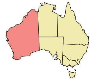
Western Australia occupies nearly one third of the Australian continent. Due to the size and the isolation of the state, considerable emphasis has been made of these features; it is the second largest administrative territory in the world, after Yakutia in Russia, despite the fact that Australia is only the sixth largest country in the world by area, and no other regional administrative jurisdiction in the world occupies such a high percentage of a continental land mass.
Its capital city, Perth, is also considered to be amongst the world's most isolated, being closer to Jakarta in Indonesia, than to the Australian national capital in Canberra.
© MMXXIII Rich X Search. We shall prevail. All rights reserved. Rich X Search
