Back Geografia del Territori Britànic de l'Oceà Índic Catalan Geografia Brytyjskiego Terytorium Oceanu Indyjskiego Polish


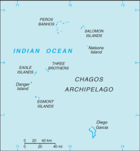
The British Indian Ocean Territory (BIOT) is an archipelago of 55 islands in the Indian Ocean, located south of India. It is situated approximately halfway between Africa and Indonesia. The islands form a semicircular group with an open sea towards the east. The largest, Diego Garcia, is located at the southern extreme end. It measures 60 square kilometres (23 sq mi) and accounts for almost three-quarters of the total land area of the territory.[1][disputed ] Diego Garcia is the only inhabited island and is home to the joint UK-US naval support facility.[2][3] Other islands within the archipelago include Danger Island, Three Brothers Islands, Nelson Island, and Peros Banhos, as well as the island groups of the Egmont Islands, Eagle Islands, and the Salomon Islands.[3]
- ^ Notholt 2008, p. 5.
- ^ Cite error: The named reference
Worldwas invoked but never defined (see the help page). - ^ a b "British Indian Ocean Territory". Encyclopædia Britannica. Retrieved 23 June 2013.
© MMXXIII Rich X Search. We shall prevail. All rights reserved. Rich X Search