Back النمذجة الجيولوجية Arabic Modélisation géologique French Геологічна модель Ukrainian Mô hình địa chất Vietnamese

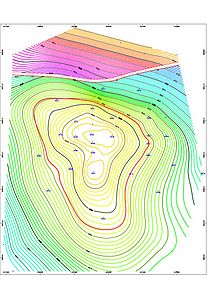
Geologic modelling, geological modelling or geomodelling is the applied science of creating computerized representations of portions of the Earth's crust based on geophysical and geological observations made on and below the Earth surface. A geomodel is the numerical equivalent of a three-dimensional geological map complemented by a description of physical quantities in the domain of interest.[1] Geomodelling is related to the concept of Shared Earth Model;[2] which is a multidisciplinary, interoperable and updatable knowledge base about the subsurface.
Geomodelling is commonly used for managing natural resources, identifying natural hazards, and quantifying geological processes, with main applications to oil and gas fields, groundwater aquifers and ore deposits. For example, in the oil and gas industry, realistic geologic models are required as input to reservoir simulator programs, which predict the behavior of the rocks under various hydrocarbon recovery scenarios. A reservoir can only be developed and produced once; therefore, making a mistake by selecting a site with poor conditions for development is tragic and wasteful. Using geological models and reservoir simulation allows reservoir engineers to identify which recovery options offer the safest and most economic, efficient, and effective development plan for a particular reservoir.
Geologic modelling is a relatively recent subdiscipline of geology which integrates structural geology, sedimentology, stratigraphy, paleoclimatology, and diagenesis;
In 2-dimensions (2D), a geologic formation or unit is represented by a polygon, which can be bounded by faults, unconformities or by its lateral extent, or crop. In geological models a geological unit is bounded by 3-dimensional (3D) triangulated or gridded surfaces. The equivalent to the mapped polygon is the fully enclosed geological unit, using a triangulated mesh. For the purpose of property or fluid modelling these volumes can be separated further into an array of cells, often referred to as voxels (volumetric elements). These 3D grids are the equivalent to 2D grids used to express properties of single surfaces.
Geomodelling generally involves the following steps:[3]
- Preliminary analysis of geological context of the domain of study.
- Interpretation of available data and observations as point sets or polygonal lines (e.g. "fault sticks" corresponding to faults on a vertical seismic section).
- Construction of a structural model describing the main rock boundaries (horizons, unconformities, intrusions, faults)[4]
- Definition of a three-dimensional mesh honoring the structural model to support volumetric representation of heterogeneity (see Geostatistics) and solving the Partial Differential Equations which govern physical processes in the subsurface (e.g. seismic wave propagation, fluid transport in porous media).
- ^ Mallet, J. L. (2008). Numerical Earth Models. European Association of Geoscientists and Engineers (EAGE Publications bv). ISBN 978-90-73781-63-4. Archived from the original on 2016-03-04. Retrieved 2013-08-20.
- ^ Fanchi, John R. (August 2002). Shared Earth Modeling : Methodologies for Integrated Reservoir Simulations. Gulf Professional Publishing (Elsevier imprint). pp. xi–306. ISBN 978-0-7506-7522-2.
- ^ Chen, Shang-Ying; Hsieh, Bieng-Zih; Hsu, Kuo-Chin; Chang, Yi-Fei; Liu, Jia-Wei; Fan, Kai-Chun; Chiang, Li-Wei; Han, Yin-Lung (January 2021). "Well spacing of the doublet at the Huangtsuishan geothermal site, Taiwan". Geothermics. 89: 101968. Bibcode:2021Geoth..8901968C. doi:10.1016/j.geothermics.2020.101968. S2CID 224972986.
- ^ Caumon, G., Collon-Drouaillet, P., Le Carlier de Veslud, C., Sausse, J. and Viseur, S. (2009), Surface-based 3D modeling of geological structures, Mathematical Geosciences, 41(9):927–945
© MMXXIII Rich X Search. We shall prevail. All rights reserved. Rich X Search