Back Giambattista Nolli Danish Giovanni Battista Nolli German Giambattista Nolli Spanish Giambattista Nolli French ג'אמבטיסטה נולי HE Giovanni Battista Nolli Italian Giambattista Nolli Malagasy Giambattista Nolli Portuguese Giovanni Battista Nolli Swedish 佐雲尼·巴迪斯塔·諾利 ZH-YUE


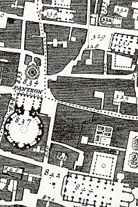
Giambattista Nolli (or Giovanni Battista) (April 9, 1701 – July 3, 1756), was an Italian architect and surveyor. He is best known for his ichnographic plan of Rome, the Pianta Grande di Roma which he began surveying in 1736 and engraved in 1748, and now universally known as the Nolli Map. The map is composed of 12 copper plate engravings that together measure 176 centimetres (69 in) by 208 centimetres (82 in). It was produced and published in response to the commission of Pope Benedict XIV to survey Rome in order to help create demarcations for the 14 traditional rioni or districts.[3] It was by far the most accurate description of Rome produced to date at a time when the architectural achievement of the Papacy was in full flower.
- ^ "GUIDETTI, Guidetto in "Dizionario Biografico"". www.treccani.it.
- ^ "Chamber of deputies- Services to the Public – Library-Services provided". Archived from the original on 2012-07-16. Retrieved 2012-09-01. ; https://www.youtube.com/view_play_list?p=FE63C3CADF407B24
- ^ Tracing Architecture, Dana Arnold, 2003
© MMXXIII Rich X Search. We shall prevail. All rights reserved. Rich X Search