Back جيزور Arabic جيزور ARZ Gisors AST Gisors BUG Gisors Catalan ЖизогӀ (ЭгӀ) CE Gisors CEB Gisors Czech Gisors German Ζιζόρ Greek
Gisors | |
|---|---|
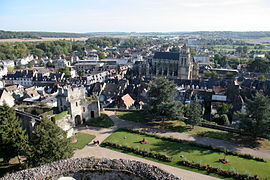
 City as seen from the castle terrasse | |
| Coordinates: 49°16′52″N 1°46′38″E / 49.2811°N 1.7772°E | |
| Country | France |
| Region | Normandy |
| Department | Eure |
| Arrondissement | Les Andelys |
| Canton | Gisors |
| Intercommunality | Vexin Normand |
| Government | |
| • Mayor (2022–2026) | José Cerqueira[1] |
| Area 1 | 16.67 km2 (6.44 sq mi) |
| Population (2021)[2] | 11,919 |
| • Density | 710/km2 (1,900/sq mi) |
| Time zone | UTC+01:00 (CET) |
| • Summer (DST) | UTC+02:00 (CEST) |
| INSEE/Postal code | 27284 /27140 |
| Elevation | 47–142 m (154–466 ft) (avg. 74 m or 243 ft) |
| 1 French Land Register data, which excludes lakes, ponds, glaciers > 1 km2 (0.386 sq mi or 247 acres) and river estuaries. | |
Gisors (French pronunciation: [ʒizɔʁ]) is a commune in the French department of Eure, Normandy, France. It is located 62.9 km (39.1 mi) northwest from the centre of Paris.
Gisors, together with the neighbouring communes of Trie-Château and Trie-la-Ville, form an urban area of 13,915 inhabitants (2018).[3] This urban area is a satellite town of Paris.
- ^ "Répertoire national des élus: les maires" (in French). data.gouv.fr, Plateforme ouverte des données publiques françaises. 6 June 2023.
- ^ "Populations légales 2021" (in French). The National Institute of Statistics and Economic Studies. 28 December 2023.
- ^ Comparateur de territoire, INSEE
© MMXXIII Rich X Search. We shall prevail. All rights reserved. Rich X Search


