Back سلسلة جبال جوجبيك ARZ Gogebic Range CEB Gogebic Range German Gisement de fer de Gogebic Range French Гогебичский хребет Russian


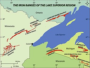
The Gogebic Range is an elongated area of iron ore deposits located within a range of hills in northern Michigan and Wisconsin just south of Lake Superior. It extends from Lake Namakagon in Wisconsin eastward to Lake Gogebic in Michigan, or almost 80 miles. Though long, it is only about a half mile wide and forms a crescent concave to the southeast. The Gogebic Range includes the communities of Ironwood in Michigan, plus Mellen and Hurley in Wisconsin.[1]
The name Gogebic is an Anglicized spelling from old style Ojibwe “googii-bi”, which loosely translates to "they dive here", most likely referring to the schools of fish that jump from the surface of Lake Gogebic. "Range" is the term commonly used for such iron ore areas around Lake Superior. In Wisconsin, the Gogebic Range is often called the Penokee Range. The range is named after Lake Gogebic, a large lake near the east end of the range in Gogebic and Ontonagon Counties in Michigan.
Located within the southern of two parallel prominent ridges, the Gogebic range iron formation name is often used interchangeably with the range of hills that encompass it. The hills composing the Gogebic range vary from 100 to 600 feet above the surrounding terrain, and are a prominent landform visible for miles. The Gabbro, or Trap Range comprises a somewhat lower ridge of hills running parallel just to the north of the Gogebic Range. Since the two ranges of hills are made up of dissimilar rock types, the rock formation containing the iron ore deposits is located exclusively within the southern (Gogebic) Range.
The Gogebic Range experienced a speculative iron boom in the mid-1880s, and had recurring booms and busts from 1884 to 1967 as demand shifted.
- ^ Aldrich, Henry (1929). The Geology of the Gogebic Iron Range of Wisconsin. State of Wisconsin. p. 5.
© MMXXIII Rich X Search. We shall prevail. All rights reserved. Rich X Search