Goose Village | |
|---|---|
| Victoriatown | |
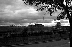
 Old Victoriatown train station, as it appeared in 2007. | |
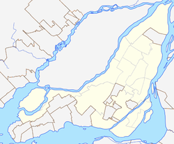
Location of Goose Village in Montreal | |
| Coordinates: 45°28′57″N 73°32′53″W / 45.48240°N 73.54802°W | |
| Country | Canada |
| Province | Quebec |
| City | Montreal |
| Borough | Le Sud-Ouest |
| Area | |
| • Land | 0.47 km2 (0.18 sq mi) |
| Elevation | 20 m (70 ft) |
| Population | |
| • Total | 0 |
| • Density | 0/km2 (0/sq mi) |
| • Population (1963) | 1,500 |
| Postal Code | |
| Area code(s) | 514, 438 |


Goose Village (French: "Village-aux-Oies") was a neighbourhood in Montreal, Quebec, Canada. Its official but less commonly used name was Victoria town,[3][4][5] after the adjacent Victoria Bridge.
The neighbourhood was built on an area formerly known as Windmill Point, where thousands of Irish immigrants died from disease in 1847 and 1848. The entire neighborhood was demolished in 1964 as part of preparations for Expo 67, to be replaced by a football stadium and parking lot.
- ^ a b "Census Profile: Census Tract 4620071.00". Canada 2011 Census. Statistics Canada. February 8, 2012. Retrieved April 2, 2012.
- ^ Cite error: The named reference
Goosewas invoked but never defined (see the help page). - ^ Montrealers Insulted by Tourist Map . Ottawa Citizen. August 20, 1948. Page 7.
- ^ "Victoria Town Deserves Respect" (Letter to Editor) Author Don Elvidge. Montreal Gazette. August 30, 1948. page 8.
- ^ "Victoria Town Not Hobo Town Says M.P. Protesting Pamphlet" Montreal Gazette. August 19, 1948. page 11
© MMXXIII Rich X Search. We shall prevail. All rights reserved. Rich X Search

