Back كوبرى الحاكم نوبرى دى كارفالو ARZ Ponte Governador Nobre de Carvalho German Puente Gobernador Nobre de Carvalho Spanish Governador Nobre de Carvalho zubia Basque Pont du gouverneur Nobre de Carvalho French Nobre de Carvalho kormányzó híd Hungarian 嘉楽庇総督大橋 Japanese 카르발류 총독 대교 Korean Ponte Governador Nobre de Carvalho Dutch Governador Nobre de Carvalho-broen NB
Governor Nobre de Carvalho Bridge
| |
|---|---|
 Governor Nobre de Carvalho Bridge at night | |
| Coordinates | 22°10′35″N 113°32′46″E / 22.17639°N 113.54611°E |
| Carries | 2 lanes |
| Crosses | Praia Grande Bay |
| Locale | Macau Peninsula and Taipa |
| Other name(s) | Macau-Taipa Bridge |
| Characteristics | |
| Design | Girder bridge |
| Total length | 2,569.8 meters (8,431 ft) → 2,436 meters (7,992 ft) |
| Width | 9.2 meters (30 ft) |
| Longest span | 73 meters (240 ft) |
| History | |
| Opened | 5 October 1974 |
| Closed | 2005–2006 |
| Statistics | |
| Daily traffic | buses and taxis |
| Toll | free |
| Location | |
 | |
| Governor Nobre de Carvalho Bridge | |||||||||||||||
|---|---|---|---|---|---|---|---|---|---|---|---|---|---|---|---|
 | |||||||||||||||
| Chinese name | |||||||||||||||
| Traditional Chinese | 嘉樂庇總督大橋 | ||||||||||||||
| Simplified Chinese | 嘉乐庇总督大桥 | ||||||||||||||
| |||||||||||||||
| Macau-Taipa Bridge | |||||||||||||||
| Traditional Chinese | 澳氹大橋 | ||||||||||||||
| Simplified Chinese | 澳氹大桥 | ||||||||||||||
| |||||||||||||||
| Second alternative Chinese name | |||||||||||||||
| Traditional Chinese | 舊大橋 | ||||||||||||||
| Simplified Chinese | 旧大桥 | ||||||||||||||
| |||||||||||||||
| Portuguese name | |||||||||||||||
| Portuguese | Ponte Governador Nobre de Carvalho | ||||||||||||||
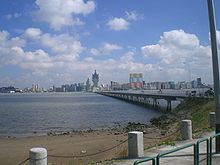
The Governor Nobre de Carvalho Bridge, also known as the Macau–Taipa Bridge, is a dual-lane two-way bridge connecting Macau Peninsula near Casino Lisboa and the island of Taipa at the northern slope of Taipa Pequena (Small Taipa Hill) crossing the former Baía da Praia Grande. It is the first bridge in Macau, to connect the peninsula and Taipa. It is locally known as "The Old Bridge" (Chinese: 舊大橋).[1]
The flag of Macau uses this bridge as an emblem.
- ^ "Governor Nobre de Carvalho Bridge". Mobile City Guide. Retrieved 2020-06-06.
© MMXXIII Rich X Search. We shall prevail. All rights reserved. Rich X Search