Back ممشى غراند كانيون Arabic Grand Canyon Skywalk German Skywalk Greek Grand Canyon Skywalk Esperanto Grand Canyon Skywalk Spanish Grand Canyon Skywalk French Passerella sul Grand Canyon Italian グランドキャニオン・スカイウォーク Japanese 그랜드 캐니언 스카이워크 Korean Grand Canyon Skywalk Dutch
Grand Canyon Skywalk | |
|---|---|
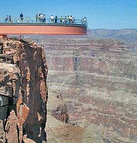
 Skywalk from Outside Ledge | |
| Coordinates | 36°0′44″N 113°48′40″W / 36.01222°N 113.81111°W |
| Carries | Pedestrian |
| Locale | Grand Canyon West, Arizona, US |
| Official name | Grand Canyon Skywalk |
| Owner | Hualapai Tribe |
| Characteristics | |
| Design | Curved pedestrian cantilever bridge |
| Material | Steel, glass |
| Total length | 70 feet (21 m) |
| Width | 10 feet 2 inches (3.10 m) |
| History | |
| Architect | Mark Ross Johnson |
| Opened | March 28, 2007 |
| Location | |
 | |
The Grand Canyon Skywalk is a horseshoe-shaped cantilever bridge with a glass walkway at Eagle Point in Arizona near the Colorado River, on the edge of a side canyon in the Grand Canyon West area of the main canyon.[1] It opened as a tourist attraction in 2007, located outside the boundaries of the Grand Canyon National Park.
USGS topographic maps indicate the Skywalk's elevation as 4,770 ft (1,450 m) above sea level. The elevation of the Colorado River at the base of the canyon below is 1,160 ft (350 m). The vertical drop directly below the skywalk is 500 to 800 feet (150 to 240 m).[2] The attraction is immediately north of Grand Canyon West Airport and about 75 miles (121 km) east of Las Vegas, Nevada, although nearly 130 miles (210 km) by car. The nearest city with a population greater than 10,000 people is Kingman, Arizona, about 50 miles (80 km) south.
Commissioned and owned by the Hualapai Indian tribe, the skywalk was unveiled March 20, 2007, and opened to the general public on March 28, 2007. The attraction's operators have reported over one million visitors per year several times, first occurring in 2015.[3]
- ^ Yost, Mark. Close to the Edge, Wall Street Journal. 2007-04-10.
- ^ Acme mapper: USGS topographic map
- ^ "Grand Canyon Skywalk, Grand Canyon West Top 1 Million Visitors For 3rd Straight Year". prnewswire.com (Press release). Grand Canyon West. December 21, 2017. Retrieved June 18, 2023.
© MMXXIII Rich X Search. We shall prevail. All rights reserved. Rich X Search