Back جبل جريات بلو هيل ARZ Great Blue Hill CEB Great Blue Hill German Great Blue Hill LLD Great Blue Hill Portuguese گریٹ بلیو ہل Urdu Buyuk koʻk togʻ Uzbek
| Great Blue Hill | |
|---|---|
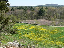
 View of Great Blue Hill from neighbouring Signal Hill | |
| Highest point | |
| Elevation | 635 ft (193.5 m)[1] |
| Prominence | 483 ft (147 m)[1] |
| Coordinates | 42°12′43″N 71°06′56″W / 42.2120434°N 71.1156064°W[2] |
| Geography | |
| Location | Norfolk County, Massachusetts |
| Parent range | Blue Hills |
| Topo map | USGS Norwood |
Great Blue Hill is a hill of 635 feet (194 m) located within the Blue Hills Reservation in Milton, Randolph and Canton, Massachusetts, about 10 miles (16 km) south of downtown Boston. It is the highest point in Norfolk County and the Greater Boston area.
The modern name for the hill was given by early English colonists who, while sailing along the coastline, noticed the bluish hue of the exposed granite faces when viewed from a distance (due to Riebeckite). The Blue Hills' eastern slopes face the ocean and lie within Quincy. The area once attracted quarrying for its "blue granite".[3]
Great Blue Hill was a point of reference for the Indians, and the local tribe were known as the "people at the large hill" (Massachuseuck). The English called them the Massachusetts, which ultimately became the name of the state.[4][5]
- ^ a b "Great Blue Hill, Massachusetts". Peakbagger.com. Retrieved 2012-12-18.
- ^ "Great Blue Hill". Geographic Names Information System. United States Geological Survey, United States Department of the Interior. Retrieved 2012-12-18.
- ^ "The Blue Hills Reservation". Massachusetts Department of Conservation and Recreation. Retrieved 2007-11-29.
- ^ Harper, Douglas. "Massachusetts". The Online Etymology Dictionary. Retrieved 9 December 2022.
- ^ "Massachusett". Oxford English Dictionary (Online ed.). Oxford University Press. (Subscription or participating institution membership required.)
© MMXXIII Rich X Search. We shall prevail. All rights reserved. Rich X Search