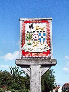
| Great Chart | |
|---|---|
 Great Chart village sign | |
Location within Kent | |
| Area | 13.31 km2 (5.14 sq mi) |
| Population | 6,801 (civil parish)[1] |
| • Density | 511/km2 (1,320/sq mi) |
| OS grid reference | TQ983422 |
| Civil parish | |
| District | |
| Shire county | |
| Region | |
| Country | England |
| Sovereign state | United Kingdom |
| Post town | Ashford |
| Postcode district | TN23 |
| Dialling code | 01233 |
| Police | Kent |
| Fire | Kent |
| Ambulance | South East Coast |
| UK Parliament | |
Great Chart is a village and former civil parish, now in the parish of Great Chart with Singleton, in the Ashford borough of Kent, England. The parish is split between the ancient village of Great Chart and the modern Singleton neighbourhood on the western outskirts of Ashford. The village centre of Great Chart is 2 miles (3.2 km) from the town centre. In 1961 the parish had a population of 969.[2]
- ^ "Key Statistics; Quick Statistics: Population Density". United Kingdom Census 2011. Office for National Statistics. Archived from the original on 11 February 2003. Retrieved 10 May 2014.
- ^ "Population statistics Great Chart AP/CP through time". A Vision of Britain through Time. Retrieved 23 September 2021.
© MMXXIII Rich X Search. We shall prevail. All rights reserved. Rich X Search

