Back غرينوود (إنديانا) Arabic جرينوود (جونسون) ARZ قرینوود، ایندیانا AZB Greenwood (Indiana) Catalan Гринвуд (Индиана) CE Greenwood (lungsod sa Tinipong Bansa, Indiana) CEB Greenwood, Indiana Welsh Greenwood (Indiana) German Greenwood (Indiana) Spanish Greenwood (Indiana) Basque
Greenwood, Indiana | |
|---|---|
City | |
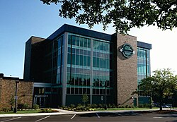
 Greenwood City Hall | |
| Nickname(s): City of Pride and Progress | |
 Location of Greenwood in Johnson County, Indiana | |
| Coordinates: 39°36′41″N 86°07′05″W / 39.61139°N 86.11806°W | |
| Country | United States |
| State | Indiana |
| County | Johnson |
| Townships | Pleasant, White River, Clark |
| Government | |
| • Mayor | Mark W. Myers (R) [1] |
| Area | |
| • Total | 27.91 sq mi (72.28 km2) |
| • Land | 27.91 sq mi (72.28 km2) |
| • Water | 0.00 sq mi (0.00 km2) |
| Elevation | 804 ft (245 m) |
| Population (2020) | |
| • Total | 63,830 |
| • Density | 2,287.24/sq mi (883.12/km2) |
| Time zone | UTC−5 (EST) |
| • Summer (DST) | UTC−4 (EDT) |
| ZIP codes | 46142-46143 |
| Area code | 317 |
| FIPS code | 18-29898[4] |
| GNIS feature ID | 2394244[3] |
| Website | www |
Greenwood is a city in Johnson County, Indiana, United States. The population was 63,830 at the 2020 Census. Greenwood is located southeast of central Indianapolis between Indiana State Road 37 and Interstate 65. The city shares a border with Indianapolis and is the most populous suburban municipality in the southern portion of the Indianapolis Metropolitan Area.
- ^ "About the Mayor". Greenwood.gov. Greenwood City Council. Retrieved July 19, 2022.
- ^ "2020 U.S. Gazetteer Files". United States Census Bureau. Retrieved March 16, 2022.
- ^ a b U.S. Geological Survey Geographic Names Information System: Greenwood, Indiana
- ^ "U.S. Census website". United States Census Bureau. Retrieved January 31, 2008.
© MMXXIII Rich X Search. We shall prevail. All rights reserved. Rich X Search

