Back كيدي ماغا Arabic غیدیماغا بؤلگهسی AZB Кудимага Bulgarian Guidimakha Catalan Guidimaka (rehiyon) CEB Guidimaka Danish Guidimaka German Γκιντιμάγκα Greek Gidimaka Esperanto Región de Guidimaka Spanish
Guidimakha
ولاية كيدي ماغة | |
|---|---|
Region | |
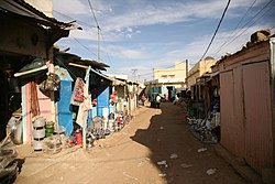
 A street in Selibaby | |
 | |
| Coordinates: 15°23′N 12°21′W / 15.383°N 12.350°W | |
| Country | |
| Departments | |
| Capital | Sélibaby |
| Area | |
| • Total | 10,300 km2 (4,000 sq mi) |
| Population (2013 census) | |
| • Total | 267,029 |
| • Density | 26/km2 (67/sq mi) |
| Time zone | UTC+0 |
| • Summer (DST) | not observed |
| HDI (2017) | 0.454[1] low |
Guidimaka (Arabic: ولاية كيدي ماغة, romanized: Wilāyat Kidi Māghah) is the southernmost region of Mauritania. Its capital is Sélibaby. The region borders the Mauritanian region of Assaba to the north-east, Mali to the south-east, Senegal to the south-west and the Mauritanian Gorgol Region to the west.[2]
As of 2013, the population of the region was 267,029, compared to 260,459 in 2011. There were 48.88 per cent females and 51.12 per cent males. As of 2008, the activity rate was 40.70 and economic dependency ratio was 1.22. As of 2008, the activity rate was 40.70 and economic dependency ratio was 1.22. As of 2008, the literacy rate for people aged 15 years and over was 27.30. The local government is headed by an elected district representative, while the elections for the local government are conducted every five years. On account of the political instability, the last elections were held in 2023.
- ^ "Sub-national HDI - Area Database - Global Data Lab". hdi.globaldatalab.org. Retrieved 2018-09-13.
- ^ Anthony G. Pazzanita Historical dictionary of Mauritania, Scarecrow Press, Lanham (Maryland) ; Toronto, Plymouth (UK), 2008 (3rd ed.), p. 231-232 ISBN 978-0-8108-5596-0
© MMXXIII Rich X Search. We shall prevail. All rights reserved. Rich X Search