Back مقاطعة غونيسون (كولورادو) Arabic Gunnison County, Colorado BAR Ганісан (акруга) Byelorussian Гънисън (окръг) Bulgarian গুন্নিসন কাউন্টি, কলোরাডো BPY Gunnison Gông (Colorado) CDO Ганнисон (гуо, Колорадо) CE Gunnison County CEB Gunnison County Czech Gunnison County, Colorado Welsh
Gunnison County | |
|---|---|
 | |
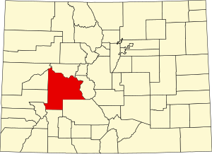
 Location within the U.S. state of Colorado | |
 Colorado's location within the U.S. | |
| Coordinates: 38°40′N 107°01′W / 38.67°N 107.01°W | |
| Country | |
| State | |
| Founded | March 9, 1877 |
| Named for | John W. Gunnison |
| Seat | Gunnison |
| Largest city | Gunnison |
| Area | |
| • Total | 3,260 sq mi (8,400 km2) |
| • Land | 3,239 sq mi (8,390 km2) |
| • Water | 21 sq mi (50 km2) 0.6% |
| Population (2020) | |
| • Total | 16,918 |
| • Density | 5.2/sq mi (2.0/km2) |
| Time zone | UTC−7 (Mountain) |
| • Summer (DST) | UTC−6 (MDT) |
| Congressional district | 3rd |
| Website | www |

Gunnison County is a county located in the U.S. state of Colorado. As of the 2020 census, the population was 16,918.[1] The county seat is Gunnison.[2] The county was named for John W. Gunnison, a United States Army officer and captain in the Army Topographical Engineers, who surveyed for the transcontinental railroad in 1853.
- ^ "State & County QuickFacts". United States Census Bureau. Retrieved September 5, 2021.
- ^ "Find a County". National Association of Counties. Retrieved June 7, 2011.
© MMXXIII Rich X Search. We shall prevail. All rights reserved. Rich X Search