Back Habsburg AG ALS هابسبورغ (سويسرا) Arabic Habsburg (Argòvia) Catalan Habsburg (lungsod) CEB Habsburg (obec) Czech Habsburg AG German Habsburgo AG Esperanto Habsburg (Argovia) Spanish Habsburg Estonian Habsburg (Argovia) Basque
Habsburg | |
|---|---|
 Habsburg village | |
 Coat of arms | |
Location of Habsburg  | |
 Habsburg  Habsburg | |
| Coordinates: 47°28′N 8°11′E / 47.467°N 8.183°E | |
| Country | Switzerland |
| Canton | Aargau |
| District | Brugg |
| Area | |
| • Total | 223 km2 (86 sq mi) |
| Elevation | 470 m (1,540 ft) |
| Population (31 December 2018)[2] | |
| • Total | 440 |
| • Density | 2.0/km2 (5.1/sq mi) |
| Time zone | UTC+01:00 (Central European Time) |
| • Summer (DST) | UTC+02:00 (Central European Summer Time) |
| Postal code(s) | 5245 |
| SFOS number | 4099 |
| ISO 3166 code | CH-AG |
| Surrounded by | Brugg, Hausen, Scherz, Schinznach-Bad |
| Website | habsburg SFSO statistics |
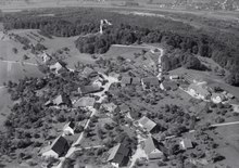
Habsburg (High Alemannic: Hapschberg) is a municipality in the district of Brugg in canton of Aargau in Switzerland. It lies about three kilometres southwest of the town of Brugg, the capital of the district of Brugg. Habsburg is named after Habsburg Castle, built around 1020–1030 for Count Radbot of the nearby county of Klettgau in the Duchy of Swabia, which Habsburg was also a part of at the time.
- ^ a b "Arealstatistik Standard - Gemeinden nach 4 Hauptbereichen". Federal Statistical Office. Retrieved 13 January 2019.
- ^ "Ständige Wohnbevölkerung nach Staatsangehörigkeitskategorie Geschlecht und Gemeinde; Provisorische Jahresergebnisse; 2018". Federal Statistical Office. 9 April 2019. Retrieved 11 April 2019.
© MMXXIII Rich X Search. We shall prevail. All rights reserved. Rich X Search