Back هاها جيما Arabic Hahajima BCL Haha Jima CEB Hahadžima Czech Haha-jima German Haha-jima Spanish هاهاجیما Persian Haha-jima French Haha-jima ID Haha-jima Italian
Native name: Japanese: 母島 | |
|---|---|
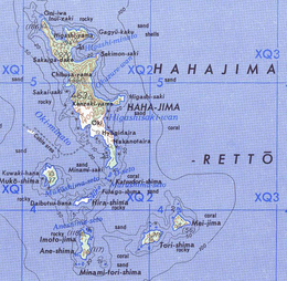
 Map of the Hahajima Rettō (Imōtojima is mislabeled as Tori-shima) | |
| Geography | |
| Location | Pacific Ocean |
| Coordinates | 26°39′N 142°10′E / 26.650°N 142.167°E |
| Archipelago | Bonin Islands |
| Area | 19.88 km2 (7.68 sq mi) |
| Highest elevation | 462 m (1516 ft) |
| Highest point | Chibusayama |
| Administration | |
Japan | |
| Prefecture | Tokyo |
| Subprefecture | Ogasawara |
| Village | Ogasawara |
| Demographics | |
| Population | 440 (2021) |
| Pop. density | 22.1/km2 (57.2/sq mi) |
| Ethnic groups | Japanese |
Hahajima, Haha Jima, or Haha-jima (母島, meaning Mother Island) is the second-largest island within the Bonin or Ogasawara Islands SSE of the Japanese Home Islands. The steeply-sloped island, which is about 21 km2 (8 sq mi) in area, has a population of 440.[1] It is part of Ogasawara Village in Ogasawara Subprefecture, which is approximately 1,000 km (620 mi) south of Tokyo, Japan.
The highest peaks Hahajima are Chibusayama (lit. Breast Mountain), approximately 462 metres (1,516 ft), and Sakaigatake, 443 metres (1,453 ft). It is part of an archipelago that includes Chichijima approximately 50 km (31 mi) to the north and the nearby smaller islands such as Anejima and Imōtojima and Mukōjima. The group forms the Hahajima Rettō (母島列島; formerly the "Baily Group").
- ^ "支庁の案内: 管内概要 (Japanese)". 2021-04-01. Retrieved 2022-06-16.
© MMXXIII Rich X Search. We shall prevail. All rights reserved. Rich X Search
