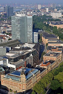
 View of Neustadt's western Wallring. In the background: Elbe and port |
The Wallring (German pronunciation: [ˈvalrɪŋ]) is a semi-circular urban ensemble encircling the inner city of Hamburg. It consists of a four-lane ring road with a total length of 3.3 kilometers (2.1 mi) and a continuous built-up street front on its inner side. The outer perimeter is – for the largest part – made up by a string of parks.
The Wallring follows the outline of Hamburg's old city wall, and was developed in the first half of the 19th century, when the defensive wall, the (Wallanlagen), was razed. The wall that defined the city's edge from the 1620s until the 1840s has had a strong impact on shaping the modern city. The Wallring park consists of several differently named sections, which — based on their common historical development — are characterized by a certain unity, but also by a number of dissimilarities. It also offers the inner city's largest network of parks, and forms a sort of connection to Hamburg's green and open spaces along Elbe and Alster.
© MMXXIII Rich X Search. We shall prevail. All rights reserved. Rich X Search

