Back هارپندن AZB Harpenden Catalan Harpenden CEB Harpenden Welsh Harpenden Spanish هارپندن Persian Harpenden French Harpenden Irish Harpenden Italian Harpenden LLD
| Harpenden | |
|---|---|
 Church Green in Harpenden town centre in spring | |
Location within Hertfordshire | |
| Area | 4.93 sq mi (12.8 km2) |
| Population | 31,128 (2021: parish) 30,674 (2021: built-up area)[1] |
| • Density | 6,314/sq mi (2,438/km2) |
| OS grid reference | TL135145 |
| Civil parish |
|
| District | |
| Shire county | |
| Region | |
| Country | England |
| Sovereign state | United Kingdom |
| Post town | HARPENDEN |
| Postcode district | AL5 |
| Dialling code | 01582 |
| Police | Hertfordshire |
| Fire | Hertfordshire |
| Ambulance | East of England |
| UK Parliament | |
| Website | Harpenden Town Council |
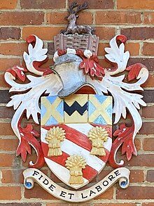
| Arms of Harpenden Town Council | |
|---|---|
 | |
| Crest | On a Wreath of the Colours within Wattled Palings proper a Mount Vert thereon a Hart lodged also proper |
| Shield | Bendy of six Gules and Argent three Garbs Or a Chief Azure thereon a Pale between two Saltires throughout of the third a Fess dancetté Sable |
| Motto | Fide Et Laborare (By Faith And Industry) |
| Granted 4 February 1949 to Harpenden Urban District Council.[3] | |
Harpenden (/ˈhɑːrpəndən/) is a town and civil parish in the City and District of St Albans in the county of Hertfordshire, England. The population of the built-up area was 30,674 in the 2021 census, while the population of the civil parish was 31,128.[4][5][6] Harpenden is a commuter town, with a direct rail connection to Central London.
- ^ ONS, Census 2021 Parish Profiles
- ^ "Harpenden Town". Mapit. Retrieved 4 July 2023.
- ^ "HARPENDEN TOWN COUNCIL (HERTS)". Robert Young. Retrieved 30 October 2019.
- ^ "Harpenden parish". NOMIS. Office for National Statistics. Retrieved 13 November 2021.
- ^ "Harpenden built-up area". NOMIS. Office for National Statistics. Retrieved 13 November 2021.
- ^ Small parts of the built-up area lie outside the parish boundary in the neighbouring parishes of Harpenden Rural and Wheathampstead.
© MMXXIII Rich X Search. We shall prevail. All rights reserved. Rich X Search
