Back هراوي (صفد) Arabic Qeren Naftali CEB Keren Naftali Czech هراوی Persian קרן נפתלי HE Harrawi ID Harrawi Polish Qeren Naftali Swedish ہراوی Urdu
Harrawi
هرّاوي/عرب الحمدون | |
|---|---|
Village | |
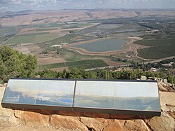
 Keren Naftali lookout | |
| Etymology: Kh. Harrah, the ruin of Harreh,from personal name.[1] | |
A series of historical maps of the area around Harrawi (click the buttons) | |
Location within Mandatory Palestine | |
| Coordinates: 33°5′27″N 35°33′47″E / 33.09083°N 35.56306°E | |
| Palestine grid | 202/277 |
| Geopolitical entity | Mandatory Palestine |
| Subdistrict | Safad |
| Date of depopulation | 1948[3] |
| Population (1931) | |
| • Total | 148[2] |
Harrawi (Arabic: هرّاوي/عرب الحمدون) was a Palestinian Arab village in the Safad Subdistrict. It was depopulated during the 1948 Arab-Israeli War on May 25, 1948, by the Palmach's First Battalion of Operation Yiftach. It was located 18 km northeast of Safad.
In 1948, it had a population of 290.
© MMXXIII Rich X Search. We shall prevail. All rights reserved. Rich X Search


