Back هاريسبورغ (إلينوي) Arabic هاريسبورج (سالين, الينوى) ARZ هریزبرق، ایلینوی AZB Гаррисбург (Иллинойс) CE Harrisburg (kapital sa kondado sa Tinipong Bansa, Illinois) CEB Harrisburg, Illinois Welsh Harrisburg DAG Harrisburg (Illinois) German Harrisburg (Illinois) Spanish Harrisburg (Illinois) Basque
Harrisburg | |
|---|---|
City | |
| City of Harrisburg | |
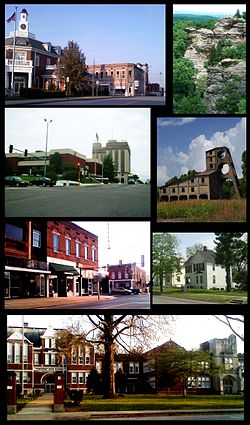
 From top left: Northern side of square, Garden of the Gods, Saline County Courthouse and Clearwave Building, O'Gara mine tipple, southern side of square, Poplar Street homes, Harrisburg Township High School | |
| Nickname(s): The Burg, H-burg | |
| Motto: Gateway to the Shawnee National Forest | |
 Location of Harrisburg in Saline County, Illinois | |
| Coordinates: 37°44′02″N 88°32′45″W / 37.73389°N 88.54583°W | |
| Country | United States |
| State | Illinois |
| County | Saline |
| Settled | 1847 |
| Founded | 1853 |
| Incorporated | 1889 |
| Government | |
| • Mayor | John McPeek |
| Area | |
| • Total | 6.81 sq mi (17.63 km2) |
| • Land | 6.61 sq mi (17.12 km2) |
| • Water | 0.20 sq mi (0.51 km2) 3.11% |
| Elevation | 397 ft (121 m) |
| Population (2020) | |
| • Total | 8,219 |
| • Density | 1,243.04/sq mi (479.97/km2) |
| Time zone | UTC−6 (CST) |
| • Summer (DST) | UTC−5 (CDT) |
| ZIP code | 62946 |
| Area code(s) | 618, 730 |
| FIPS code | 17-33136 |
| Website | www.thecityofharrisburgil.com |
Harrisburg (/ˈhærɪsbɜːrɡ, ˈhɛərz-/) is a city in and the county seat of Saline County, Illinois, United States.[2] It is located about 57 miles (92 kilometers) southwest of Evansville, Indiana, and 111 mi (179 km) southeast of St. Louis, Missouri. Its 2020 population was 8,219, and the surrounding Harrisburg Township had a population of 10,037, including the city residents. Harrisburg is included in the Illinois–Indiana–Kentucky tri-state area and is the principal city in the Harrisburg micropolitan statistical area with a combined population of 24,913.[3]
Located at the concurrency of U.S. Route 45, Illinois Route 13, Illinois Route 145, and Illinois Route 34, Harrisburg is known as the "Gateway to the Shawnee National Forest",[4] and is also known for the Ohio River flood of 1937, the old Crenshaw House (also known as the Old Slave House), the Tuttle Bottoms Monster, prohibition-era gangster Charlie Birger, and the 2012 EF4 tornado. A Cairo and Vincennes Railroad boomtown, the city was one of the leading bituminous coal-mining distribution hubs of the American Midwest between 1900 and 1937.
At its peak, Harrisburg's population reached 16,000 by the early 1930s. The city had one of the largest downtown districts in Southern Illinois.[5] The city was the 20th-most populated city in Illinois outside the Chicago metropolitan area and the most-populous city in Southern Illinois outside the Metro East in 1930.[6] However, the city has seen an economic decline due to the decreased demand for high-sulfur coal, the removal of the New York Central railroad, and tributary lowlands leaving, much area around the city unfit for growth due to flood risks.
- ^ "2020 U.S. Gazetteer Files". United States Census Bureau. Retrieved March 15, 2022.
- ^ "Find a County". National Association of Counties. Retrieved June 7, 2011.
- ^ "Annual Estimates of the Population of Metropolitan and Micropolitan Statistical Areas: April 1, 2000 to July 1, 2007 (CBSA-EST2007-01)". 2007 Population Estimates. United States Census Bureau, Population Division. March 27, 2008. Archived from the original (CSV) on July 9, 2010. Retrieved July 3, 2008.
- ^ "Community Profile Presents, Harrisburg". Harrisburg Illinois Library. Retrieved April 6, 2009.
- ^ Schwieterman, Joseph P. (2001). When the Railroad Leaves Town: American Communities in the Age of Rail Line Abandonment, Eastern United States. Kirksville, Missouri: Truman State University Press. p. 59. ISBN 978-0-943549-97-2.
- ^ Carolyn Stewart, ACSD. "Decennial US Census". Retrieved September 13, 2014.
© MMXXIII Rich X Search. We shall prevail. All rights reserved. Rich X Search
