Back مقاطعة هاريسون (ميسيسيبي) Arabic Harrison County, Mississippi BAR Харисън (окръг, Мисисипи) Bulgarian হারিসোন কাউন্টি, মিসিসিপি BPY Harrison Gông (Mississippi) CDO Харрисон (гуо, Миссисипи) CE Harrison County (kondado sa Tinipong Bansa, Mississippi) CEB Harrison County, Mississippi Welsh Harrison County (Mississippi) Danish Harrison County (Mississippi) German
Harrison County | |
|---|---|
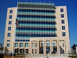
 Dan M. Russell Jr. United States Courthouse in Gulfport, Harrison County | |
 Location within the U.S. state of Mississippi | |
 Mississippi's location within the U.S. | |
| Coordinates: 30°25′N 89°05′W / 30.42°N 89.09°W | |
| Country | |
| State | |
| Founded | 1841 |
| Named for | William Henry Harrison |
| Seat | Biloxi and Gulfport |
| Largest city | Gulfport |
| Area | |
| • Total | 976 sq mi (2,530 km2) |
| • Land | 574 sq mi (1,490 km2) |
| • Water | 402 sq mi (1,040 km2) 41% |
| Population (2020) | |
| • Total | 208,621 |
| • Estimate (2022) | 211,044 |
| • Density | 362/sq mi (140/km2) |
| Time zone | UTC−6 (Central) |
| • Summer (DST) | UTC−5 (CDT) |
| Congressional district | 4th |
| Website | harrisoncountyms |
Harrison County is a county located in the U.S. state of Mississippi. As of the 2020 census, the population was 208,621.[1] Its county seats are Biloxi and Gulfport.[2] The county is named after U.S. President William Henry Harrison.[3]
Harrison County is part of the Gulfport-Biloxi metropolitan area.
The county was severely damaged from both Hurricane Camille on August 17, 1969, and Hurricane Katrina on August 29, 2005, causing catastrophic effects.
- ^ "State & County QuickFacts". United States Census Bureau. Retrieved September 15, 2023.
- ^ "Find a County". National Association of Counties. Retrieved June 7, 2011.
- ^ Gannett, Henry (1905). The Origin of Certain Place Names in the United States. Govt. Print. Off. pp. 150.
© MMXXIII Rich X Search. We shall prevail. All rights reserved. Rich X Search

