Back هاستينغس (نبراسكا) Arabic هاستينجس ARZ هیستینقز، نبراسکا AZB Хейстингс (Небраска) Bulgarian Hastings (Nebraska) Catalan Гастингс (Небраска) CE Hastings (kapital sa kondado sa Tinipong Bansa, Nebraska) CEB Hastings, Nebraska Welsh Hastings, Nebraska DAG Hastings (Nebraska) German
Hastings, Nebraska | |
|---|---|
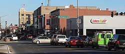
 Downtown Hastings: 2nd Street, looking eastward, November 2012 | |
 | |
| Coordinates: 40°35′46″N 98°23′24″W / 40.59611°N 98.39000°W | |
| Country | United States |
| State | Nebraska |
| County | Adams |
| Area | |
| • Total | 15.05 sq mi (38.97 km2) |
| • Land | 14.87 sq mi (38.51 km2) |
| • Water | 0.18 sq mi (0.46 km2) |
| Elevation | 1,926 ft (587 m) |
| Population (2020) | |
| • Total | 25,152 |
| • Density | 1,691.46/sq mi (653.09/km2) |
| Time zone | UTC−6 (CST) |
| • Summer (DST) | UTC−5 (CDT) |
| ZIP codes | 68901-68902 |
| Area code | 402 |
| FIPS code | 31-21415 |
| GNIS ID | 838051[2] |
| U.S. Routes | |
| Website | cityofhastings |
Hastings is a city and the county seat of Adams County, Nebraska, United States.[3] The population was 25,152 at the 2020 census, making it the 8th most populous city in Nebraska.
Edwin Perkins invented Kool-Aid in Hastings in 1927; the town celebrates the invention with the Kool-Aid Days festival every August.[4][5]
During World War II, Hastings operated the largest Naval Ammunition Depot in the United States, and for this reason was awarded the distinction of American World War II Heritage City by the National Park Service in 2023.[6]
- ^ "ArcGIS REST Services Directory". United States Census Bureau. Retrieved September 18, 2022.
- ^ a b U.S. Geological Survey Geographic Names Information System: Hastings, Nebraska
- ^ "Find a County". National Association of Counties. Retrieved June 7, 2011.
- ^ "Kool-Aid Days". Archived 2019-07-01 at the Wayback Machine Retrieved 2012-11-16.
- ^ "History: Kool-Aid: Hastings Museum". Hastings Museum. Archived from the original on February 5, 2009. Retrieved February 24, 2009.
- ^ "National Park Service 2023-24 American WWII Heritage Cities".
© MMXXIII Rich X Search. We shall prevail. All rights reserved. Rich X Search