Back Hentiesbaai Afrikaans Hentiesbaai CEB Henties Bay German Henties Bay Spanish Henties Bay Finnish Henties Bay French Hentie's Bay Italian Henties Bay Polish ہینٹیز بے ( نمیبیا) PNB Hentie's Bay Romanian
Henties Bay
| |
|---|---|
City | |
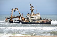
 Henties Bay (2018) | |
| Coordinates: 22°07′06″S 14°16′57″E / 22.1184°S 14.2824°E | |
| Country | |
| Region | Erongo Region |
| Constituency | Arandis Constituency |
| Established | 1929 |
| Government | |
| • Mayor | Lewies Vermaak |
| Population (2011)[1] | |
| • Total | 4,720 |
| Time zone | UTC+2 (South African Standard Time) |
| Climate | BWk |
| Website | hentiesbaytourism |

22°14′28″S 014°21′13″E / 22.24111°S 14.35361°E
Henties Bay (English, literally: Henty's Bay. Afrikaans: Hentiesbaai, German: Hentiesbucht) is a coastal town[2] in the Erongo Region of western Namibia. It is located 72 kilometres (45 mi) north of Swakopmund and is a holiday and retirement settlement, with angling a popular activity.[3] It also serves as a gateway to the seal colony of Cape Cross, which lies 46 kilometres (29 mi) to the north of the town.[4] The town had 4,720 inhabitants in 2011, an increase from 3,285 in 2001.[1] The mayor of Henties Bay is Lewies Vermaak.[5]
- ^ a b "Table 4.2.2 Urban population by Census years (2001 and 2011)" (PDF). Namibia 2011 - Population and Housing Census Main Report. Namibia Statistics Agency. p. 40. Retrieved 19 May 2017.
- ^ "Local Authorities". Association of Local Authorities in Namibia (ALAN). Archived from the original on 10 June 2013. Retrieved 1 October 2012.
- ^ Victor Tonchi; William A. Lindeke; John J. Grotpeter (2012). Historical Dictionary of Namibia. Scarecrow Press. p. 165. ISBN 9780810853980.
- ^ Anthony Ham; James Bainbridge; Lucy Corne; Mary Fitzpatrick; Trent Holden; Brendan Sainsbury (2017). Lonely Planet Southern Africa. Lonely Planet. p. 674. ISBN 9781787012400.
- ^ Hartmann, Adam (18 August 2022). "Mayor welcomes all to festival". Republikein.
© MMXXIII Rich X Search. We shall prevail. All rights reserved. Rich X Search

