| Canadian High Arctic tundra | |
|---|---|
 Truelove Lowlands, Devon Island | |
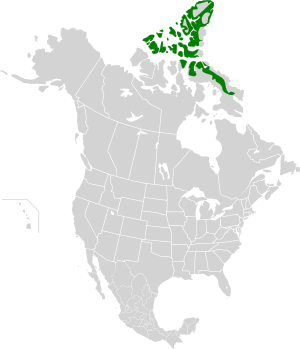
 Ecoregion territory (in green) | |
| Ecology | |
| Realm | Neoarctic |
| Biome | Tundra |
| Borders | |
| Bird species | 44[1] |
| Mammal species | 10[1] |
| Geography | |
| Area | 464,788 km2 (179,456 sq mi) |
| Country | Canada |
| Territories | Northwest Territories and Nunavut |
| Coordinates | 75°15′N 89°45′W / 75.25°N 89.75°W |
| Climate type | Polar |
| Conservation | |
| Conservation status | Relatively Stable/Intact[2] |
| Habitat loss | 0%[1] |
| Protected | 9.9%[1] |
The Canadian High Arctic Tundra ecoregion encompasses most of the northern Arctic archipelago, from much of Baffin Island, Somerset Island, and Prince of Wales Island in the south, through all islands northward to the most northern island in Canada, Ellesmere Island.[3] Much of the northern islands are covered in ice, and the climate is very dry with as little as 50 mm/year in places. The ecoregion has very little human habitation, and most of the non-ice terrain is moss and lichen cover. The region supports viable populations of arctic mammals such as muskox, arctic wolves, arctic foxes, arctic hares, polar bears, and caribou.[2][4][5][6]
- ^ a b c d "The Atlas of Global Conservation". maps.tnc.org. Archived from the original on 2012-03-05. Retrieved 2020-11-13.
- ^ a b "High Arctic tundra". World Wildlife Federation. Retrieved March 21, 2020.
- ^ https://www.oneearth.org/ecoregions/canadian-high-arctic-tundra/
- ^ "Map of Ecoregions 2017". Resolve, using WWF data. Retrieved September 14, 2019.
- ^ "High Arctic tundra". Digital Observatory for Protected Areas. Retrieved August 1, 2020.
- ^ "High Arctic tundra". The Encyclopedia of Earth. Retrieved August 28, 2020.
© MMXXIII Rich X Search. We shall prevail. All rights reserved. Rich X Search
