Highland Park | |
|---|---|
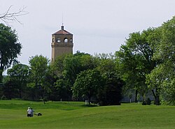
 The old Highland Park Water Tower, listed on the National Register of Historic Places. | |
 | |
| Coordinates: 44°55′4″N 93°10′1″W / 44.91778°N 93.16694°W | |
| Country | United States |
| State | Minnesota |
| County | Ramsey |
| City | Saint Paul |
| Area | |
| • Total | 6.038 sq mi (15.64 km2) |
| Population (2020)[2] | |
| • Total | 25,111 |
| • Density | 4,200/sq mi (1,600/km2) |
| Time zone | UTC-6 (CST) |
| • Summer (DST) | UTC-5 (CDT) |
| ZIP code | 55116 |
| Area code | 651 |
| Website | http://www.highlanddistrictcouncil.org/ |
Highland Park is a neighborhood in the southwestern corner of Saint Paul, Minnesota, United States. Also known as Highland District Council (District 15), it lies along the Mississippi River just north of Fort Snelling and across the river from Minneapolis–Saint Paul International Airport. According to the 2000 census Highland Park had a population of 23,202.
- ^ "Highland neighborhood in Saint Paul, Minnesota (MN) detailed profile". City-Data. 2013. Retrieved 2017-03-08.
- ^ "Saint Paul Neighborhood Profile: Highland". Minnesota Compass. October 2011. Retrieved 2017-03-08.
© MMXXIII Rich X Search. We shall prevail. All rights reserved. Rich X Search
