| Hikurangi Margin | |
|---|---|
| Hikurangi Subduction Zone | |
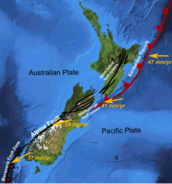
 The Hikurangi Margin is an active fault off the east coast of the North Island of New Zealand. This shows variation in displacement vector of Pacific Plate relative to the Kermadec Plate and Australian Plate along the boundary. The Kermadec Trench label would better read Hikurangi Trench at this position. The Kermadec Plate is not labelled but lies between the labels of the North Island Fault System and the Kermadec Trench in the picture. | |
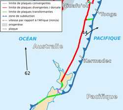
 The relationship of the Kermadec Plate to its New Zealand portion whose eastern margin is the Hikurangi Subduction Zone and the Tonga Plate. | |
| Etymology | Hikurangi |
| Country | New Zealand |
| Region | North Island |
| Characteristics | |
| Length | 300 km (190 mi) |
| Displacement | 6 cm (2.4 in)/yr |
| Tectonics | |
| Plate | Indo-Australian |
| Status | Active |
| Earthquakes | Mw8.2 |
| Type | Subduction |
| Age | Miocene-Holocene |
| New Zealand geology database (includes faults) | |
The Hikurangi Margin (also known as the Hikurangi Subduction Zone) is New Zealand's largest subduction zone and fault.[1]
- ^ Wallace, Laura; Clark, Kate (29 November 2017). "Hikurangi subduction zone - GeoNet: News". GeoNet. GNS Science. Retrieved 29 August 2022.
The Hikurangi subduction zone (sometimes referred to as the Hikurangi subduction margin) is New Zealand's largest fault
© MMXXIII Rich X Search. We shall prevail. All rights reserved. Rich X Search
