Back Hilo Afrikaans هيلو (هاواي) Arabic هيلو ARZ हीलो AWA هیلو، هاوایی AZB Хіла (Гаваі) Byelorussian Гіла (Гаваі) BE-X-OLD Хило Bulgarian Hilo Catalan Гило CE
Hilo, Hawaii | |
|---|---|
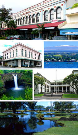
 From top to bottom, left to right: S. Hata Building, Hilo Masonic Lodge Hall-Bishop Trust Building, Hilo Bay with Mauna Kea, Rainbow (Waiānuenue) Falls, Federal Building, Post Office and Courthouse and Liliuokalani Park and Gardens. | |
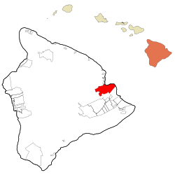
 Location within Hawaii County and Hawaii | |
| Coordinates: 19°42′20″N 155°5′9″W / 19.70556°N 155.08583°W | |
| Country | United States |
| State | Hawaii |
| County | Hawaii |
| Government | |
| • Mayor | Mitch Roth |
| Area | |
| • Total | 58.3 sq mi (151.0 km2) |
| • Land | 53.4 sq mi (138.3 km2) |
| • Water | 4.9 sq mi (12.7 km2) |
| Elevation | 20 ft (6 m) |
| Population | |
| • Total | 44,186 |
| • Density | 760/sq mi (290/km2) |
| Time zone | UTC−10 (Hawaii-Aleutian) |
| ZIP Code | 96720-96721 |
| Area code | 808 |
| FIPS code | 15-14650 |
| GNIS ID | 359187[1] |
Hilo /ˈhiːloʊ/ (Hawaiian pronunciation: [ˈhilo]) is the largest settlement in Hawaii County, Hawaii, United States,[1] which encompasses the Island of Hawaii, and is a census-designated place (CDP). The population was 44,186 according to the 2020 census.[2] It is the fourth-largest settlement in the state of Hawaii and largest settlement in the state outside of Oahu.
Hilo is the county seat of the County of Hawaiʻi and is in the District of South Hilo.[3] The city overlooks Hilo Bay and has views of two shield volcanoes, Mauna Loa, an active volcano, and Mauna Kea, a dormant volcano. The Hilo bay-front has been destroyed by tsunamis twice. The majority of human settlement in Hilo stretches from Hilo Bay to Waiākea-Uka, on the flanks of the volcanoes.
Hilo is home to the University of Hawaiʻi at Hilo, ʻImiloa Astronomy Center, as well as the Merrie Monarch Festival, a week-long celebration, including three nights of competition, of ancient and modern hula that takes place annually after Easter. Hilo is also home to the Mauna Loa Macadamia Nut Corporation, one of the world's leading producers of macadamia nuts. Hilo is served by Hilo International Airport.[4]
- ^ a b c "Hilo, Hawaii", Geographic Names Information System, United States Geological Survey, United States Department of the Interior
- ^ a b "U.S. Census Bureau QuickFacts: Hilo CDP, Hawaii". Census.gov. Retrieved 2022-07-20.
- ^ "Find a County". National Association of Counties. Archived from the original on May 31, 2011. Retrieved 2011-06-07.
- ^ "Hilo CDP, Hawaii Archived 2011-11-24 at the Wayback Machine." U.S. Census Bureau. Retrieved on May 21, 2009.
© MMXXIII Rich X Search. We shall prevail. All rights reserved. Rich X Search

