Back هينسديل (نيوهامشير) Arabic هینزدئیل، نیوهمپشایر AZB Hinsdale (Nou Hampshire) Catalan Гинсдейл (Нью-Гэмпшир) CE Hinsdale, New Hampshire Welsh Hinsdale (Nuevo Hampshire) Spanish هینزدیل، نیوهمپشایر Persian Hinsdale (New Hampshire) French Hinsdale, New Hampshire HT Hinsdale (New Hampshire) Italian
Hinsdale, New Hampshire | |
|---|---|
Town | |
 Town Hall | |
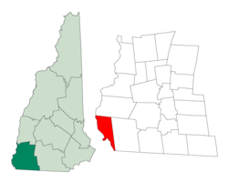
 Location in Cheshire County, New Hampshire | |
| Coordinates: 42°47′10″N 72°29′11″W / 42.78611°N 72.48639°W | |
| Country | United States |
| State | New Hampshire |
| County | Cheshire |
| Incorporated | 1753 |
| Villages |
|
| Government | |
| • Board of Selectmen |
|
| • Town Administrator | Kathryn Lynch |
| Area | |
| • Total | 22.7 sq mi (58.7 km2) |
| • Land | 20.5 sq mi (53.1 km2) |
| • Water | 2.1 sq mi (5.5 km2) 9.42% |
| Elevation | 217 ft (66 m) |
| Population (2020)[2] | |
| • Total | 3,948 |
| • Density | 192/sq mi (74.3/km2) |
| Time zone | UTC-5 (Eastern) |
| • Summer (DST) | UTC-4 (Eastern) |
| ZIP code | 03451 |
| Area code | 603 |
| FIPS code | 33-36660 |
| GNIS feature ID | 0873626 |
| Website | www |
Hinsdale is a town in Cheshire County, New Hampshire, United States. The population was 3,948 at the 2020 census.[2] Hinsdale is home to part of Pisgah State Park in the northeast, and part of Wantastiquet Mountain State Forest in the northwest.
The main village in town, where 1,485 people resided at the 2020 census, is defined as the Hinsdale census-designated place (CDP) and is located at the junction of New Hampshire routes 119 and 63.
- ^ "2021 U.S. Gazetteer Files – New Hampshire". United States Census Bureau. Retrieved November 3, 2021.
- ^ a b "Hinsdale town, Cheshire County, New Hampshire: 2020 DEC Redistricting Data (PL 94-171)". U.S. Census Bureau. Retrieved November 3, 2021.
© MMXXIII Rich X Search. We shall prevail. All rights reserved. Rich X Search