Hoddle Highway (Hoddle Main Road) Hoddle Street, Punt Road, Barkly Street | |
|---|---|
 | |
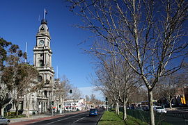
| Hoddle Street looking south, with the Collingwood Town Hall on the left | |
| Coordinates | |
| General information | |
| Type | Highway |
| Length | 10.9 km (6.8 mi)[1] |
| Gazetted | September 1960 (as Main Road)[2] September 1994 (as State Highway)[3] |
| Route number(s) |
|
| Major junctions | |
| North end | Fitzroy North, Melbourne |
| South end | Elwood, Melbourne |
| Location(s) | |
| Major suburbs | Collingwood, Abbotsford, Richmond, South Yarra, Prahran, Windsor, St Kilda |
| Highway system | |
| ---- | |
Hoddle Highway is an urban highway in Melbourne linking CityLink and the Eastern Freeway, itself a sub-section of Hoddle Main Road. Both these names are not widely known to most drivers, as the entire allocation is still best known as by the names of its constituent parts: Hoddle Street, Punt Road and Barkly Street.[4][5] This article will deal with the entire length of the corridor for sake of completion.
The highway is named after the surveyor Robert Hoddle, who planned central Melbourne's Hoddle Grid.[citation needed]
- ^ Google (19 October 2021). "Hoddle Main Road" (Map). Google Maps. Google. Retrieved 19 October 2021.
- ^ "Victorian Government Gazette". State Library of Victoria. 7 September 1960. pp. 2977–81. Retrieved 23 May 2024.
- ^ "Victorian Government Gazette". State Library of Victoria. 8 September 1994. pp. 2411–2. Retrieved 30 December 2021.
- ^ Cite error: The named reference
vicreg-hhwas invoked but never defined (see the help page). - ^ Cite error: The named reference
vicreg-hmrwas invoked but never defined (see the help page).
© MMXXIII Rich X Search. We shall prevail. All rights reserved. Rich X Search

