Back Ahaggar Afrikaans جبال هقار Arabic جبال هقار ARZ Ахагар Byelorussian Ахагар Bulgarian আহাগ্গার পর্বতশ্রেণী Bengali/Bangla Ahaggar Catalan Ahaggar (ibabaw'mg patag) CEB Ahaggar Czech Mynyddoedd Ahaggar Welsh
| Hoggar Mountains | |
|---|---|
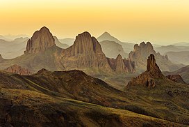
 Landscape of the Assekrem region in the Hoggar in Tamanrasset Province | |
| Highest point | |
| Peak | Mount Tahat |
| Elevation | 2,908 m (9,541 ft) |
| Coordinates | 23°17′20″N 05°32′01″E / 23.28889°N 5.53361°E |
| Naming | |
| Native name |
|
| Geography | |
| Country | Algeria |
| Hoggar National Park | |
|---|---|
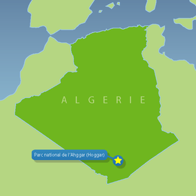
 Locator map | |
| Location | Tamanrasset Province, Algeria |
| Nearest city | Tamanrasset |
| Coordinates | 22°08′N 6°10′E / 22.133°N 6.167°E |
| Area | 450,000 km2 (170,000 sq mi) |
| Established | 1987 |
 | |
The Hoggar Mountains (Arabic: جبال هقار, Berber: idurar n Ahaggar) are a highland region in the central Sahara in southern Algeria, along the Tropic of Cancer. The mountains cover an area of approximately 550,000 km2.[1]
The Hoggar Mountains are home to the Ahaggar National Park, one of the national parks of the country.[2] The tallest peak in the range and Algeria, Mount Tahat, is located in the park area, which covers approximately 450,000 square kilometres (170,000 sq mi).[2]
- ^ Scheffel, Richard L.; Wernet, Susan J., eds. (1980). Natural Wonders of the World. United States of America: Reader's Digest Association, Inc. pp. 32–33. ISBN 0-89577-087-3.
- ^ a b "Ahaggar National Park, Saharan Algeria Region, Algeria". Algeria.com. Archived from the original on 13 November 2022. Retrieved 27 May 2020.
© MMXXIII Rich X Search. We shall prevail. All rights reserved. Rich X Search
