Back نظام الإحداثيات الأفقية Arabic Coordenaes horizontales AST Гарызантальная сістэма каардынат Byelorussian Coordenades horitzontals Catalan Obzorníkové souřadnice Czech Horizontales Koordinatensystem German Οριζόντιες συντεταγμένες Greek Coordenadas horizontales Spanish Horisondilised koordinaadid Estonian Koordenatu horizontalen sistema Basque

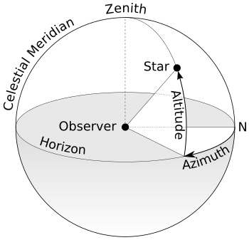
The horizontal coordinate system is a celestial coordinate system that uses the observer's local horizon as the fundamental plane to define two angles: altitude and azimuth. Therefore, the horizontal coordinate system is sometimes called the az/el system,[1] the alt/az system, or the alt-azimuth system, among others. In an altazimuth mount of a telescope, the instrument's two axes follow altitude and azimuth.[2]
© MMXXIII Rich X Search. We shall prevail. All rights reserved. Rich X Search