Back هورسيشو فالس ARZ Podkova (Niagarské vodopády) Czech Horseshoe Falls German Horseshoe Falls Spanish Horseshoe ur-jauziak Basque آبشار نعل اسب Persian Chutes du Fer-à-Cheval French カナダ滝 Japanese Grojogan Tapel Jaran JV 호스슈 폭포 Korean
| Horseshoe Falls | |
|---|---|
 | |
 | |
| Location | Border of Ontario, Canada, and New York, United States. Canada to the right in the photo. |
| Coordinates | 43°04′38″N 79°04′32″W / 43.077305°N 79.07562°W |
| Type | Cataract |
| Total height | 167 ft (51 m)[1] |
| Total width | 2,700 ft (820 m)[1] |
| Watercourse | Niagara River |
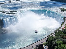
Horseshoe Falls is the largest of the three waterfalls that collectively form Niagara Falls on the Niagara River along the Canada–United States border. Approximately 90% of the Niagara River, after diversions for hydropower generation, flows over Horseshoe Falls. The remaining 10% flows over American Falls and Bridal Veil Falls. It is located between Terrapin Point on Goat Island in the US state of New York, and Table Rock in the Canadian province of Ontario.[2] These falls are also referred to as the Canadian Falls.[3][4]
- ^ a b "Niagara Falls". World Waterfalls Database. Retrieved January 28, 2017.
- ^ "The international boundary line may pass through the Horseshoe Falls just beyond Terrapin Tower Point, so that the United States are not entitled to as large a portion as Canada of the Horseshoe Falls, which is admittedly not all Canadian." Statement of Mr. J Boardman Scovell. Preservation of Niagara Falls: hearings on the subject of H.R. 26688, Sixty-first Congress, second session, relating to the control and regulation of the waters of Niagara River and the preservation of Niagara Falls, held before the Committee on Rivers and Harbors of the House of Representatives. U.S. G.P.O., 1911
- ^ "Canadian Falls". Info Niagara. 2021.
- ^ "Niagara Falls (Waterfalls)". The Canadian Encyclopedia. April 22, 2013.
© MMXXIII Rich X Search. We shall prevail. All rights reserved. Rich X Search