Back རྨ་ལྷོ་བོད་རིགས་རང་སྐྱོང་ཁུལ་ Tibetan Uòng-nàng CDO Huangnan Zangzu Zizhizhou CEB Chuang-nan Czech Huangnan Danish Huangnan German Prefectura autónoma tibetana de Huangnan Spanish Huangnan Tibetar Prefektura autonomoa Basque ولایت خودمختار هوانگنان تبتی Persian Huangnanin tiibetiläisten autonominen prefektuuri Finnish
Huangnan Prefecture
黄南州 · རྨ་ལྷོ་ཁུལ། Malho | |
|---|---|
| Huangnan Tibetan Autonomous Prefecture 黄南藏族自治州 · རྨ་ལྷོ་བོད་རིགས་རང་སྐྱོང་ཁུལ་ | |
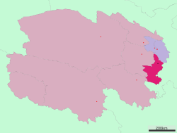
 Location of Huangnan Tibetan Autonomous Prefecture in Qinghai | |
| Coordinates: 35°31′09″N 102°00′55″E / 35.5193°N 102.0154°E | |
| Country | People's Republic of China |
| Province | Qinghai |
| Prefecture seat | Tongren County |
| Area | |
| • Total | 18,226 km2 (7,037 sq mi) |
| Population (2020)[1] | |
| • Total | 276,215 |
| • Density | 15/km2 (39/sq mi) |
| GDP[2] | |
| • Total | CN¥ 7.3 billion US$ 1.2 billion |
| • Per capita | CN¥ 27,181 US$ 4,364 |
| Time zone | UTC+8 (China Standard) |
| ISO 3166 code | CN-QH-23 |
Huangnan Tibetan Autonomous Prefecture (simplified Chinese: 黄南藏族自治州; traditional Chinese: 黃南藏族自治州; pinyin: Huángnán Zàngzú Zìzhìzhōu; Tibetan: རྨ་ལྷོ་བོད་རིགས་རང་སྐྱོང་ཁུལ་, Wylie: rma lho bod rigs rang skyong khul) is an autonomous prefecture of Eastern Qinghai, China, bordering Gansu to the east. The prefecture has an area of 17,921 km2 (6,919 sq mi) and its seat is in Tongren County.
- ^ 青海省统计局 青海省第七次全国人口普查领导小组办公室. "青海省第七次全国人口普查公报(第二号)". 青海省统计局. Archived from the original on 2022-10-06. Retrieved 2023-01-01.
- ^ 青海省统计局、国家统计局青海调查总队 (August 2016). 《青海统计年鉴-2016》. 中国统计出版社. ISBN 978-7-5037-7834-6. Archived from the original on 2017-12-28. Retrieved 2017-06-05.
© MMXXIII Rich X Search. We shall prevail. All rights reserved. Rich X Search