Back مطار هدسون فالى الاقليمى ARZ Dutchess County Airport CEB فرودگاه شهرستان دوتچس Persian Aeroportul Regional Hudson Valley Romanian Фурудгоҳи шаҳристон дутчс Tajik ڈیچیز کاؤنٹی ایئرپورٹ Urdu
Hudson Valley Regional Airport | |||||||||||||||||||
|---|---|---|---|---|---|---|---|---|---|---|---|---|---|---|---|---|---|---|---|
 | |||||||||||||||||||
 | |||||||||||||||||||
| Summary | |||||||||||||||||||
| Airport type | Public | ||||||||||||||||||
| Owner | Dutchess County | ||||||||||||||||||
| Serves | Poughkeepsie, New York | ||||||||||||||||||
| Elevation AMSL | 164 ft / 50 m | ||||||||||||||||||
| Coordinates | 41°37′36″N 073°53′03″W / 41.62667°N 73.88417°W | ||||||||||||||||||
| Website | POU Website | ||||||||||||||||||
| Maps | |||||||||||||||||||
 FAA airport diagram | |||||||||||||||||||
 | |||||||||||||||||||
| Runways | |||||||||||||||||||
| |||||||||||||||||||
| Statistics (2014) | |||||||||||||||||||
| |||||||||||||||||||
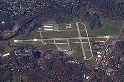
Hudson Valley Regional Airport (IATA: POU, ICAO: KPOU, FAA LID: POU), formerly known as Dutchess County Airport, is a county-owned public-use airport located on State Route 376 in the Town of Wappinger, Dutchess County, New York, United States, four miles (6 km) south of the central business district of Poughkeepsie.[1] It is sometimes called Poughkeepsie Airport, which gives it the code POU. The airport provides corporate and general aviation transportation services.
- ^ a b FAA Airport Form 5010 for POU PDF, effective 2015-06-25
© MMXXIII Rich X Search. We shall prevail. All rights reserved. Rich X Search