| Hume Dam | |
|---|---|
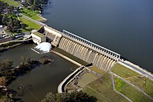
 The Hume Dam and spillway, 2012 | |
Location of the Hume Dam in New South Wales | |
| Country | Australia |
| Location | Riverina, New South Wales |
| Coordinates | 36°06′30″S 147°01′52″E / 36.10833°S 147.03111°E |
| Purpose | Flood mitigation, hydro-power, irrigation, water supply and conservation |
| Status | Operational |
| Construction began | 1919 |
| Opening date | 1936 |
| Construction cost | A£2.1 million[1] |
| Owner(s) | Murray-Darling Basin Authority |
| Dam and spillways | |
| Type of dam | Gravity dam |
| Impounds | Murray River |
| Height | 51 metres (167 ft) |
| Length | 1,615 metres (5,299 ft) |
| Spillways | 29 |
| Spillway type | Vertical undershot gated concrete overflow |
| Spillway capacity | 7,929 cubic metres per second (280,000 cu ft/s) |
| Reservoir | |
| Creates | Lake Hume |
| Total capacity | 3,036,500 megalitres (2,461,700 acre⋅ft) |
| Active capacity | 1,417,188 megalitres (1,148,933 acre⋅ft) |
| Inactive capacity | 1,619,312 megalitres (1,312,798 acre⋅ft) |
| Catchment area | 15,300 square kilometres (5,900 sq mi) |
| Surface area | 20,190 hectares (49,900 acres) |
| Maximum water depth | 40 metres (130 ft) |
| Normal elevation | 192 metres (630 ft) AHD |
| Power Station | |
| Operator(s) | Eraring Energy |
| Commission date | 1957 |
| Type | Conventional |
| Turbines | 2 |
| Installed capacity | 58 megawatts (78,000 hp) |
| Annual generation | 220 gigawatt-hours (790 TJ) |
| Website Hume Dam at www.statewater.com.au | |
Hume Dam, formerly the Hume Weir, is a major dam across the Murray River downstream of its junction with the Mitta River in the Riverina region of New South Wales, Australia. The dam's purpose includes flood mitigation, hydro-power, irrigation, water supply and conservation. The impounded reservoir is called Lake Hume, formerly the Hume Reservoir. It is a gated concrete gravity dam with four earth embankments and twenty-nine vertical undershot gated concrete overflow spillways.
- ^ "£2m. Hume Weir Power Station". The Advertiser. National Library of Australia. 27 January 1949. p. 1. Retrieved 19 April 2013.
© MMXXIII Rich X Search. We shall prevail. All rights reserved. Rich X Search

