Back مقاطعة هونتردون (نيو جيرسي) Arabic Hanterdon (dairə, Nyu-Cersi) Azerbaijani Hunterdon County, New Jersey BAR Хънтърдън (окръг, Ню Джърси) Bulgarian হান্টারডন কাউন্টি, নিউ জার্সি BPY Hunterdon Gông (New Jersey) CDO Хантердон (гуо, Нью-Джерси) CE Hunterdon County CEB Hunterdon County, New Jersey Welsh Hunterdon County German
Hunterdon County | |
|---|---|
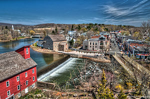
 A view of Clinton, New Jersey with Red Mill (in the foreground) and the downtown district across the Raritan River (in the background) | |
 Location within the U.S. state of New Jersey | |
 New Jersey's location within the U.S. | |
| Coordinates: 40°34′N 74°55′W / 40.57°N 74.92°W | |
| Country | |
| State | |
| Founded | 1714 |
| Named for | Robert Hunter |
| Seat | Flemington[1] |
| Largest municipality | Raritan Township (population) Readington Township (area) |
| Government | |
| • Commission Director | Zachary T. Rich (R, term ends December 31, 2023) |
| Area | |
| • Total | 437.40 sq mi (1,132.9 km2) |
| • Land | 427.84 sq mi (1,108.1 km2) |
| • Water | 9.56 sq mi (24.8 km2) 2.2% |
| Population | |
| • Total | 128,947 |
| • Estimate | 130,183 |
| • Density | 301.4/sq mi (116.4/km2) |
| Congressional district | 7th |
| Website | www |
Hunterdon County is a county located in the western section of the U.S. state of New Jersey. At the 2020 census, the county was the state's 18th-most populous county,[6] with a population of 128,947,[3][4] its highest decennial count ever and an increase of 598 (+0.5%) from the 2010 census count of 128,349,[7] which in turn reflected an increase of 6,360 (5.2%) from the 121,989 counted in the 2000 census.[8] Its county seat is Flemington.[1] The county is part of the Central Jersey region of the state.[9][10]
In 2015, the county had a per capita personal income of $80,759, the third-highest in New Jersey and ranked 33rd of 3,113 counties in the United States.[11][12] The Bureau of Economic Analysis ranked the county as having the 19th-highest per capita income of all 3,113 counties in the United States (and the highest in New Jersey) as of 2009.[13] In 2011, Hunterdon County had the second-lowest level of child poverty of any county in the United States.[14]
Geographically, much of the county lies in the Delaware Valley. Local businesses and the Delaware Valley Regional High School carry the name. However, it is part of the New York-Northern New Jersey-Long Island metropolitan statistical area (MSA) and part of the larger New York-Newark Combined Statistical Area (CSA).[15]
Hunterdon County was established on March 11, 1714, separating from Burlington County, at which time it included all of present-day Morris, Sussex, and Warren counties.[16] The rolling hills and rich soils which produce bountiful agricultural crops drew Native American tribes and then Europeans to the area.
- ^ a b New Jersey County Map, New Jersey Department of State. Accessed December 22, 2022.
- ^ Cite error: The named reference
CensusAreawas invoked but never defined (see the help page). - ^ a b c Cite error: The named reference
Census2020was invoked but never defined (see the help page). - ^ a b Cite error: The named reference
LWD2020was invoked but never defined (see the help page). - ^ Cite error: The named reference
PopEstwas invoked but never defined (see the help page). - ^ Table1. New Jersey Counties and Most Populous Cities and Townships: 2020 and 2010 Censuses, New Jersey Department of Labor and Workforce Development. Accessed December 1, 2022.
- ^ Cite error: The named reference
Census2010was invoked but never defined (see the help page). - ^ DP-1 - Profile of General Demographic Characteristics: 2000; Census 2000 Summary File 1 (SF 1) 100-Percent Data for Hunterdon County, New Jersey, United States Census Bureau. Accessed January 21, 2013.
- ^ Governor Murphy Settles Central Jersey Debate, Governor of New Jersey Phil Murphy, press release dated August 4, 2023. "Governor Phil Murphy today signed S3206 to promote Central Jersey tourism.... The 'Central Jersey' region will be comprised of, at minimum, the counties of Hunterdon, Mercer, Middlesex, and Somerset."
- ^ Willis, David P. "'This is how wars start': Does Central Jersey include both Ocean and Union counties?", Asbury Park Press, February 20, 2023. Accessed March 31, 2024. "North Jersey is defined as Sussex, Warren, Morris, Passaic, Bergen, Essex and Hudson counties; South Jersey would be Burlington, Camden, Gloucester, Atlantic, Salem, Cumberland and Cape May counties. But for Central, things get a little tricky. It would include Hunterdon, Somerset, Union, Middlesex, Mercer, Monmouth, and Ocean counties."
- ^ 250 Highest Per Capita Personal Incomes available for 3113 counties in the United States: 2015, New Jersey Department of Labor and Workforce Development. Accessed October 24, 2017.
- ^ Local Area Personal Income: 2015 Archived October 15, 2017, at the Wayback Machine, Bureau of Economic Analysis. Accessed October 24, 2017.
- ^ 250 Highest Per Capita Personal Incomes of the 3113 Counties in the United States, 2009 Archived December 12, 2011, at the Wayback Machine, Bureau of Economic Analysis. Hunterdon has the highest per capita personal income for counties with under 250,000 people. Accessed April 9, 2012.
- ^ Small Area Income and Poverty Estimates - Table 1: 2011 Poverty and Median Income Estimates - Counties Archived October 10, 2013, at the Wayback Machine, United States Census Bureau. Accessed January 8, 2015.
- ^ "Revised Delineations of Metropolitan Statistical Areas, Micropolitan Statistical Areas, and Combined Statistical Areas, and Guidance on Uses of the Delineations of These Areas", OMB Bulletin no. 18-04, The White House, Office of Management and Budget, September 4, 2018
- ^ Snyder, John P. The Story of New Jersey's Civil Boundaries: 1606-1968 Archived June 5, 2012, at the Wayback Machine, Bureau of Geology and Topography; Trenton, New Jersey; 1969. p. 153. Accessed May 30, 2012.
© MMXXIII Rich X Search. We shall prevail. All rights reserved. Rich X Search


