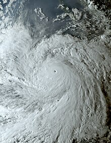
 Jova at peak intensity on September 7 | |
| Meteorological history | |
|---|---|
| Formed | September 4, 2023 |
| Remnant low | September 10, 2023 |
| Dissipated | September 14, 2023 |
| Category 5 major hurricane | |
| 1-minute sustained (SSHWS/NWS) | |
| Highest winds | 160 mph (260 km/h) |
| Lowest pressure | 926 mbar (hPa); 27.34 inHg |
| Overall effects | |
| Fatalities | None reported |
| Damage | $251,000 (2023 USD) |
| Areas affected | Western Mexico, Baja California peninsula, Southwestern United States |
Part of the 2023 Pacific hurricane season | |
Hurricane Jova was a very powerful tropical cyclone that became the first Pacific hurricane to reach Category 5 strength on the Saffir-Simpson scale since Willa in 2018. Jova was also one of the fastest–intensifying tropical cyclones on record in the Eastern Pacific tropical cyclone basin.[1] Jova was the tenth named storm, seventh hurricane, fifth major hurricane[a] and first Category 5 hurricane of the 2023 Pacific hurricane season.
Jova originated from a tropical wave that entered the Pacific Ocean on September 1. The system briskly organized and became a tropical depression the following day. After brief inhibition by wind shear, Jova explosively organized over the next two days. It formed a prominent central dense overcast on September 5 and nascent eye feature, signaling its intensification into a hurricane. In a 24-hour period ending early on September 7, Jova's maximum sustained winds increased by 90 mph (150 km/h) to its peak of 160 mph (260 km/h) and its central pressure fell 67 mbar (hPa; 1.89 inHg) to its minimum of 926 mbar (hPa; 27.43 inHg).[3] This made it a Category 5 hurricane and was one of the five-fastest periods of intensification on record in the basin. Thereafter, an eyewall replacement cycle and decreasing sea surface temperatures caused the storm to steadily weaken. It fell below major hurricane status on September 8 and further weakened to a tropical storm on September 9. The total collapse of convection on September 10 marked its degeneration into a remnant low. The system later dissipated on September 12 as it opened up into a trough.
Jova's expansive cloud shield led to some rainfall in western states of Mexico with minor flooding occurring in Baja California Sur. Large waves and rip currents affected coastal areas from Sinaloa northward to the San Francisco Bay Area in California. Flooding in Arizona inflicted $250,000 in damage.
- ^ Masters, Jeff; Henson, Bob (September 7, 2023). "Hurricane Lee rapidly intensifying, expected to hit Cat 5". New Haven, Connecticut: Yale Climate Connections. Archived from the original on September 7, 2023. Retrieved September 14, 2023.
- ^ Saffir–Simpson Hurricane Wind Scale. National Hurricane Center (Report). National Oceanic and Atmospheric Administration. May 23, 2013. Archived from the original on September 25, 2014. Retrieved May 6, 2019.
- ^ Bucci, Lisa (February 3, 2023). Tropical Cyclone Report: Hurricane Jova (PDF) (Report). National Hurricane Center. Archived (PDF) from the original on February 1, 2024. Retrieved February 3, 2024.
Cite error: There are <ref group=lower-alpha> tags or {{efn}} templates on this page, but the references will not show without a {{reflist|group=lower-alpha}} template or {{notelist}} template (see the help page).
© MMXXIII Rich X Search. We shall prevail. All rights reserved. Rich X Search
