Hurst Spit | |
|---|---|
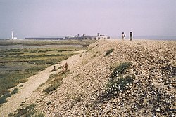
 Hurst Spit, looking south-east towards the lighthouse and castle | |
| Coordinates: 50°42′23″N 1°33′04″W / 50.7063°N 1.5511°W | |
| Grid position | SZ316897 |
| Location | Hampshire, England |
Hurst Spit is a one-mile-long (1.6 km) shingle bank near the village of Keyhaven, at the western end of the Solent, on the south coast of England. The spit shelters an area of saltmarsh and mudflats known as Keyhaven and Pennington marshes. At the end of the spit is Hurst Castle, an artillery fortress originally built on the orders of King Henry VIII, and much enlarged in the 19th century. Hurst Point Lighthouse was built on the end of Hurst Spit in the 1860s.
© MMXXIII Rich X Search. We shall prevail. All rights reserved. Rich X Search

