Back مخطط مائي Arabic Hydrograff Welsh Ganglinie German Hidrograma Spanish Hüdrograaf Estonian Hidrograma Basque هیدروگراف Persian Hydrogramme French Hidrograma Galician Idrogramma Italian
This article needs additional citations for verification. (April 2018) |

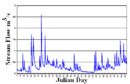
A hydrograph is a graph showing the rate of flow (discharge) versus time past a specific point in a river, channel, or conduit carrying flow. The rate of flow is typically expressed in cubic meters or cubic feet per second (cms or cfs). Hydrographs often relate changes of precipitation to changes in discharge over time.[1] It can also refer to a graph showing the volume of water reaching a particular outfall, or location in a sewerage network. Graphs are commonly used in the design of sewerage, more specifically, the design of surface water sewerage systems and combined sewers.
- ^ Sherman, LeRoy K. (1932). "The relation of hydrographs of runoff to size and character of drainage-basins". Transactions, American Geophysical Union. 13 (1): 332–339. Bibcode:1932TrAGU..13..332S. doi:10.1029/TR013i001p00332. ISSN 0002-8606.
© MMXXIII Rich X Search. We shall prevail. All rights reserved. Rich X Search