Back Bosques de abedules boreales de Islandia y tundra alpina Spanish Tundra alpina e foresta di betulle islandese Italian Бореальні березові ліси та альпійська тундра Ісландії Ukrainian Boreoale berkebusschn en alpiene toendra in Ysland VLS
| Iceland boreal birch forests and alpine tundra | |
|---|---|
 In Þingvellir National Park, Iceland | |
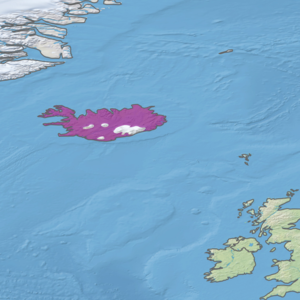
 Ecoregion territory (in purple) | |
| Ecology | |
| Realm | Palearctic |
| Biome | Boreal forest/taiga |
| Geography | |
| Area | 91,681 km2 (35,398 sq mi) |
| Country | Iceland |
| Coordinates | 65°45′N 16°15′W / 65.75°N 16.25°W |
The Iceland boreal birch forests and alpine tundra ecoregion (WWF ID: PA0602) covers the island of Iceland in the North Atlantic. The island is volcanic in origin with basaltic soils, and the cold northerly climate prevents any significant crop agriculture. Because the island is young and isolated from larger land masses, species biodiversity is relatively low. Forest cover has been reduced to about 1% of the original birch forest by a long history of timber extraction and soil erosion caused by sheep grazing. Blanket bogs (areas of high rainfall and peat accumulation) are common.[1][2][3][4]
- ^ "Iceland boreal birch forests and alpine tundra". World Wildlife Federation. Retrieved March 21, 2020.
- ^ "Map of Ecoregions 2017". Resolve, using WWF data. Retrieved September 14, 2019.
- ^ "Iceland boreal birch forests and alpine tundra". Digital Observatory for Protected Areas. Retrieved August 1, 2020.
- ^ "Iceland boreal birch forests and alpine tundra". The Encyclopedia of Earth. Retrieved August 28, 2020.
© MMXXIII Rich X Search. We shall prevail. All rights reserved. Rich X Search