Back عيلام (محافظة) Arabic ايلام (محافظه) ARZ Provincia d'Ilam AST Илам (остан) AV İlam ostanı Azerbaijani ایلام اوستانی AZB Ілам (астан) BE-X-OLD Илам (остан) Bulgarian ইলম প্রদেশ Bengali/Bangla Província d'Ilam Catalan
Ilam Province | |
|---|---|
 Landscape of the province | |
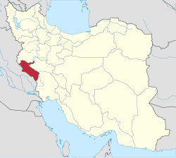
 Location of Ilam Province in Iran | |
| Coordinates: 33°11′N 46°40′E / 33.183°N 46.667°E[1] | |
| Country | Iran |
| Region | Region 4 |
| Founded | 1974 |
| Capital | Ilam |
| Counties | 12 |
| Government | |
| • Governor-general | Hassan Bahramnia |
| • MPs of Assembly of Experts | Seyed Mohsen Saeedi Golpaygani |
| • Representative of the Supreme Leader | Allah Noor Karimi Tabar |
| Area | |
| • Province | 20,164.11 km2 (7,785.41 sq mi) |
| • Urban | 30.13 km2 (11.63 sq mi) |
| • Rank | 22nd |
| Latest measurement in 2019 | |
| Highest elevation [5] (Kan Seifi Peak) | 2,775 m (9,104 ft) |
| Lowest elevation | 36 m (118 ft) |
| Population (2016)[7] | |
| • Province | 580,158 |
| • Estimate (2024)[8] | 904,000 |
| • Rank | 31st (last) |
| • Density | 29/km2 (75/sq mi) |
| • Urban | 395,263 |
| • Rural | 184,444 |
| Time zone | UTC+03:30 (IRST) |
| Postal code | 69311–69991[9] |
| Area code | +98 84 |
| Vehicle registration | Iran 98[10] |
| Main language(s) | Persian (official) local languages:[11] Kurdish Luri Arabic |
| HDI (2017) | 0.815[12] very high · 8th |
| Website | Ilam Portal |
Ilam Province (Persian: استان ایلام)[a] is one of the 31 provinces of Iran. Its capital is the city of Ilam.[15] The province is in the western part of the country in Region 4 and covers 20,164.11 km2 (7,785.41 sq mi). It shares 425 km (264 mi) of the border with Iraq, and also bordering on the provinces of Kermanshah, Lorestan, and Khuzestan.
At the time of the 2006 National Census, the population of Ilam province was 530,464 in 110,515 households.[16] The following census in 2011 counted 557,599 people in 135,499 households.[17] As of the 2016 census, the population of the province was 580,158 people in 159,310 households. Ilam is presently the least populated province in Iran.[7]
- ^ OpenStreetMap contributors (23 May 2024). "Ilam Province" (Map). OpenStreetMap. Retrieved 23 May 2024.
- ^ سالنامه آماری کشور سال ۱۳۹۷ [Statistical Yearbook of Iran Year 1397] (in Persian). Tehran, Iran: مرکز آمار ایران. 2019. Archived from the original on 1 March 2016. Retrieved 12 June 2020.
- ^ a b c السادات حائری, زهرا (2019). سالنامه آماری استان ایلام سال ۱۳۹۷ [Statistical Yearbook of Ilam Province in 1397] (in Persian). Ilam, Iran: سازمان مدیریت و برنامهریزی استان ایلام.
- ^ "هواشناسی ایلام". www.ilammet.ir. Retrieved 8 June 2020.
- ^ قله "کان صیفی" ایلام در هوای برفی فتح شد (in Persian). Ilam Press. Ilam Press. 10 January 2015. Retrieved 17 September 2015.
- ^ Google Earth Pro V 7.1.5.1557. Mehran County, Iran. 32° 58’ 53.80”N, 46° 05’ 47.61”E, Eye alt 1760 meters: US Dept of State Geographer. Google 2015. Cnes/Spot Image 2015. 22 December 2002. Archived from the original on 8 September 2010. Retrieved 18 September 2015.
{{cite book}}: CS1 maint: location (link) - ^ a b "Census of the Islamic Republic of Iran, 1395 (2016)". AMAR (in Persian). The Statistical Center of Iran. p. 16. Archived from the original (Excel) on 1 November 2020. Retrieved 19 December 2022.
- ^ "پيشبينی جمعيت كل كشور به تفكيك استان و مناطق شهری و روستايی و برحسب جنس از سال ۱۳۹۶ تا ۱۴۱۵" [Predicting the total population of the country by province and urban and rural areas and by gender from 1396 to 1415 SH]. Statistical Center of Iran (Microsoft Excel). 28 May 2018. Retrieved 12 June 2020.
- ^ کدپستی ۵ رقمی مناطق استان ایلام. سامانه پیامک برتر (in Persian). Archived from the original on 31 August 2015. Retrieved 18 September 2015.
- ^ راهنمای کامل شماره پلاک خودرو به تفکیک شهر و استان. Setareh (in Persian). مجله اینترنتی ستاره. 17 May 2015. Retrieved 17 September 2015.
- ^ Cite error: The named reference
:10was invoked but never defined (see the help page). - ^ "Sub-national HDI - Area Database - Global Data Lab". hdi.globaldatalab.org. Retrieved 13 September 2018.
- ^ "کوردستان میدیا: نوێنەری شارەکانی دێهلوڕان، ئابدانان و دەڕەشار لە مەجلیسی رێژیمی ئێران گوتی، هەنووکە لە پارێزگای ئیلام زۆربەی پڕۆژەکان بە نیوەچڵی ماونەتەوە" (in Kurdish). Archived from the original on 29 November 2022. Retrieved 18 March 2020.
- ^ "Ji sedî 2ê xelkê Îlamê madeyên hişber bi kar tînin". Rûdaw (in Kurdish). 1 September 2019. Retrieved 18 March 2020.
- ^ Habibi, Hassan (21 June 1369). "Approval of the organization and chain of citizenship of the elements and units of the national divisions of Ilam Province, centered in the city of Ilam". Lamtakam (in Persian). Ministry of Interior, Defense Political Commission of the Government Council. Archived from the original on 8 February 2024. Retrieved 8 February 2024.
- ^ "Census of the Islamic Republic of Iran, 1385 (2006)". AMAR (in Persian). The Statistical Center of Iran. p. 16. Archived from the original (Excel) on 20 September 2011. Retrieved 25 September 2022.
- ^ "Census of the Islamic Republic of Iran, 1390 (2011)". Syracuse University (in Persian). The Statistical Center of Iran. p. 16. Archived from the original (Excel) on 17 January 2023. Retrieved 19 December 2022.
Cite error: There are <ref group=lower-alpha> tags or {{efn}} templates on this page, but the references will not show without a {{reflist|group=lower-alpha}} template or {{notelist}} template (see the help page).
© MMXXIII Rich X Search. We shall prevail. All rights reserved. Rich X Search