Back بحيرة إليامنا Arabic بحيره ايليامنا ARZ Илиамна Bulgarian Llac Iliamna Catalan Iliamna (jezero) Czech Илиамна (кӳлĕ) CV Iliamna Lake German Λίμνη Ιλιάμνα Greek Lago Iliamna Spanish Iliamna aintzira Basque
| Iliamna Lake | |
|---|---|
| |
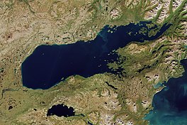
 Satellite image of Iliamna Lake | |
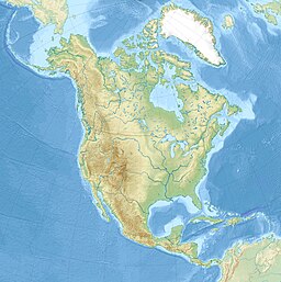
| Location | Lake and Peninsula Borough, Alaska |
| Coordinates | 59°32′12″N 155°01′28″W / 59.53667°N 155.02444°W[1] |
| Lake type | oligotrophic |
| Primary inflows | Newhalen River, Iliamna River, Pile River, Copper River |
| Primary outflows | Kvichak River |
| Basin countries | United States |
| Max. length | 77 mi (124 km)[2] |
| Max. width | 22 mi (35 km)[2] |
| Surface area | 1,012.5 sq mi (2,622 km2)[2] |
| Average depth | 144 ft (44 m)[2] |
| Max. depth | 988 ft (301 m)[2] |
| Water volume | 115.5 km3 (27.7 cu mi)[2] |
| Residence time | 7.8 years[2] |
| Surface elevation | 46 ft (14 m)[1] |
| Settlements | Iliamna, Newhalen, Kokhanok, Pedro Bay, Igiugig |
| References | [1][2] |
Iliamna Lake or Lake Iliamna (/ɪliˈæmnə/;[3] Yup'ik: Nanvarpak; Dena'ina Athabascan: Nila Vena) is a lake in southwest Alaska, at the north end of the Alaska Peninsula, between Kvichak Bay and Cook Inlet, about 100 miles (160 km) west of Seldovia, Alaska.[1] It shares a name with the Iliamna River, which flows into it, and the nearby community of Iliamna, Alaska.
It is the largest lake in Alaska, 7th largest lake in the United States, and twenty-fourth in North America. Covering about 2,600 km2 (1,000 sq mi), Iliamna Lake is 77 miles (124 km) long and up to 22 miles (35 km) wide, with a maximum depth of 988 feet (301 m). Through the Kvichak River, its waters drain into Bristol Bay.[4]
- ^ a b c d U.S. Geological Survey Geographic Names Information System: Iliamna Lake
- ^ a b c d e f g h Mathisen, Ole A.; Norma Jean Sands; Norma Haubenstock (July 2002). "Trophic ranking of biota in Iliamna Lake, Alaska" (PDF). Verh. Internat. Verein. Limnol. 28. Stuttgart: 1060–1065. Retrieved 2008-11-13. [dead link]
- ^ "Iliamna Lake - A Land Worth Preserving". YouTube. Retrieved 9 August 2024.
- ^ "Profile of the People and Land of the United States". US Department of Interior, National Atlas of the United States. Archived from the original on 2012-09-15.
© MMXXIII Rich X Search. We shall prevail. All rights reserved. Rich X Search

