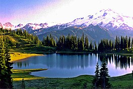
| Image Lake | |
|---|---|
 Image Lake at sunset | |
| Location | Cascade Range, Snohomish County, Washington |
| Coordinates | 48°12′27″N 121°0′30″W / 48.20750°N 121.00833°W |
| Type | Tarn |
| Primary outflows | Miners Creek |
| Catchment area | Skagit River |
| Basin countries | United States |
| Surface area | 3–4 acres (1.2–1.6 ha) |
| Surface elevation | 6,056 ft (1,846 m) |
| References | [1][2][3] |
Image Lake is a tarn in Glacier Peak Wilderness, in the North Cascades of Washington, United States.[1][3] The lake is surrounded by Plummer Peak to the east, a lookout point to the west, the Miners Creek drainage and Glacier Peak to the south, and Canyon Lake to the north.[3][4][5] The course of the popular[4][6] Miners Ridge Trail skirts the lake.[3][5] Glacier Peak can be seen from the outlet of the lake, and the peak reflected in the lake is a popular photographic subject.[4]
As a result of a relatively mild temperate climate with ample precipitation, the areas around Image Lake boast rich natural habitats with many species of plants, insects, rodents, and large mammals. Native Americans took advantage of these resources, and may have inhabited the area seasonally. However, human activity such as hunting, fishing, and mining, and recreational overuse increased after the arrival of Europeans. As a result, some areas experienced significant environmental degradation near the end of the nineteenth century and the early twentieth century, including the eradication of large predatory animals. Recreational overuse and the presence of livestock were especially problematic in the early to mid-twentieth century.
- ^ a b "Image Lake". Geographic Names Information System. United States Geological Survey, United States Department of the Interior. September 10, 1979. Retrieved July 22, 2013.
- ^ "Decision Card for Image Lake". United States Forest Service, April 10, 1940. Retrieved October 19, 2013.
- ^ a b c d Image Lake, WA — N48.19932° W121.01539° (Map). 1:24K. USGS 7.5 minute series. 2008–2013. Retrieved July 28, 2013.
- ^ a b c Spring, Ira; Manning, Harvey (1998). 100 Classic Hikes in Washington — Ira Spring, Harvey Manning — Google Books (published July 31, 1998). pp. 94–95. ISBN 978-1-59485-384-5. Retrieved July 27, 2013.
{{cite book}}:|work=ignored (help) - ^ a b "Mt. Baker-Snoqualmie National Forest — Miners Ridge Trail 785". United States Forest Service. Retrieved July 22, 2013.
- ^ Smith, Bernard A. (October 27–29, 1978). Written at Portland, Oregon. Recreational Impact on Wildlands: Conference Proceedings. University of Minnesota: Department of Agriculture, Forest Service, Pacific Northwest Region (published 1979). pp. 280–283. Retrieved July 23, 2013.
© MMXXIII Rich X Search. We shall prevail. All rights reserved. Rich X Search


