Back Independence Pass German کوه ایندیپندنز Persian Col Independence French ഇൻഡിപെൻഡൻസ് പാസ് Malayalam Independence Pass Dutch
| Independence Pass | |
|---|---|
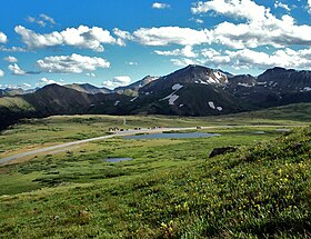
 View across pass from slopes of unnamed peak to the north | |
| Elevation | 12,095 feet (3,687 m) NAVD 88[1] |
| Traversed by | |
| Location | Lake / Pitkin counties, Colorado, U.S. |
| Range | Sawatch |
| Coordinates | 39°06′29″N 106°33′52″W / 39.10806°N 106.56444°W[1] |
| Topo map | USGS Independence Pass |
Independence Pass, originally known as Hunter Pass, is a high mountain pass in central Colorado, United States. It is at elevation 12,095 ft (3,687 m) on the Continental Divide in the Sawatch Range of the Rocky Mountains. The pass is midway between Aspen and Twin Lakes, on the border between Pitkin and Lake counties.
State Highway 82 traverses it, and after Cottonwood Pass to the south, is the second highest elevation of a paved Colorado state highway on a through road.[Note 1] It is also the second-highest pass with an improved road in the state, the fourth-highest paved road in the state[2] and the second highest paved crossing of the Continental Divide in the U.S.[3] Because of the heavy snowfall at its elevation, it is closed in wintertime,[4] isolating Aspen from direct access from the east during the ski season.
When the pass is open in warmer weather, it is a popular destination. A scenic overlook near the pass allows visitors to take in the alpine tundra environment above treeline, and offers excellent views to the east of Mount Elbert, Colorado's highest peak and the second-highest mountain in the contiguous United States. Rock climbers are drawn to nearby bouldering opportunities, and informal paths lead to nearby mountain summits of even higher elevation. Backcountry skiers make use of the slopes during the late spring and early summer. Since 2011 the pass has been on the route of the USA Pro Cycling Challenge.
The pass was formed by glacial action and erosion in the region, and its first recorded sighting was by Zebulon Pike in 1806. Ferdinand Hayden surveyed it in 1873. As part of the Continental Divide, it was the limit of European settlement in the region at the time, with the land to the west reserved for the Ute people. Prospectors who defied governor Frederick Walker Pitkin's order crossed the pass on July 4, 1879, giving it its current name and setting up a similarly named village (now a ghost town) to its west. A toll road built across the pass was abandoned and neglected after a railroad connection was made to Aspen. A new road replaced it in the 1920s; portions of the old route can still be seen along the western approach.[5] The Independence Pass Foundation, based in Aspen, works to repair damage to the pass's environment caused by both roads since 1984.
- ^ a b "E 159". NGS Data Sheet. National Geodetic Survey, National Oceanic and Atmospheric Administration, United States Department of Commerce. Retrieved 2011-02-28.
- ^ Magsamen, Kurt (2002). Cycling Colorado's Mountain Passes. Golden, CO: Fulcrum Publishing. p. 106. ISBN 9781555912949. Retrieved August 23, 2012.
- ^ Gregory, Lee (1996). Colorado Scenic Guide: Northern Region. Neenah, WI: Big Earth Publishing. p. 148. ISBN 9781555661441. Retrieved August 23, 2012.
- ^ "Can Lake County afford to wait while they fix the pass?". Colorado Central Magazine. December 1999. Archived from the original on March 17, 2012. Retrieved August 23, 2012.
- ^ "Independence Pass History". Colorado Department of Transportation. June 25, 2012. Retrieved August 17, 2012.
Cite error: There are <ref group=Note> tags on this page, but the references will not show without a {{reflist|group=Note}} template (see the help page).
© MMXXIII Rich X Search. We shall prevail. All rights reserved. Rich X Search
